|
search place name
|
||
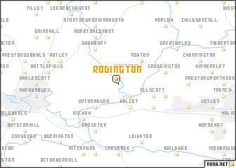
Rodington (United Kingdom)Rodington is a town in United Kingdom. An overview map of the region around Rodington is displayed below.
regional and 3d topo map of Rodington, United Kingdom ::
Rodington airports ::
The nearest airport is CEG - Hawarden, located 55.1 km north west of Rodington.
Other airports nearby include BHX - Birmingham (66.6 km south east), LPL - Liverpool (68.6 km north), MAN - Manchester (72.7 km north), CVT - Coventry (87.1 km south east), Nearby towns ::
Withington (2.2km south east) //
High Ercall (2.2km north east) //
Walcot (3.9km south) //
Upton Magna (4.3km south west) //
Rowton (4.3km north east) //
Allscott (3.8km south east) //
Wrockwardine (5.0km south east) //
Shawbury (6.0km north) //
Admaston (4.9km east) //
Crudgington (4.9km east) //
Atcham (6.5km south west) //
Wroxeter (7.7km south) //
Moreton Corbet (7.7km north) //
[all distances 'as the bird flies' and approximate] 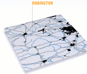 Places with similar names to Rodington, United Kingdom ::
// Redington (US)
// Reddington (US)
// Redington (US)
// Redington (US)
// Readington (US)
// Redington (US)
// Reddington (JM)
// Raddington (GB)
// Ruddington (GB)
// Hrad Nečtiny (CZ)
Disclaimer :: Information on this page comes without warranty of any kind |
||
|
Where is Rodington? Elevation and coordinates ::
Latitude (lat): 52°44'0"N Longitude (lon): 2°37'0"W
Elevation (approx.): 56m (map arrows pan, magnifying glasses zoom) |
||
|
Visiting Rodington? Hotel/Accommodation ::
Book a hotel in Rodington Travel Guide ::
rental cars ::
car rental offers GPS waypoint ::
download a GPX waypoint (PoI) of Rodington for your GPS receiver
|
||