|
search place name
|
||
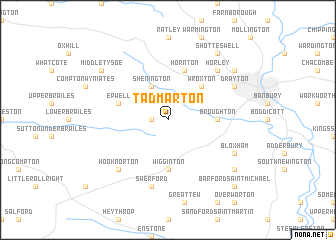
Tadmarton (United Kingdom)Tadmarton is a town in United Kingdom. An overview map of the region around Tadmarton is displayed below.
regional and 3d topo map of Tadmarton, United Kingdom ::
Tadmarton airports ::
The nearest airport is OXF - Oxford Kidlington, located 23.2 km south of Tadmarton.
Other airports nearby include BZZ - Brize Norton (33.2 km south), CVT - Coventry (37.6 km north), FFD - Fairford (46.2 km south west), BHX - Birmingham (51.5 km north west), Nearby towns ::
Swalcliffe (1.1km west) //
Shenington (3.9km north) //
Wroxton (4.4km north east) //
Broughton (3.4km east) //
Wigginton (5.6km south) //
Hornton (5.7km north) //
Epwell (3.9km north west) //
Swerford (7.5km south) //
Horley (6.5km north east) //
Hook Norton (6.5km south west) //
Bloxham (5.9km south east) //
Drayton (5.9km north east) //
Hanwell (7.2km north east) //
Barford Saint John (7.2km south east) //
Middle Tysoe (7.2km north west) //
Shotteswell (8.2km north east) //
Barford Saint Michael (8.7km south east) //
[all distances 'as the bird flies' and approximate] 
Disclaimer :: Information on this page comes without warranty of any kind |
||
|
Where is Tadmarton? Elevation and coordinates ::
Latitude (lat): 52°2'0"N Longitude (lon): 1°26'0"W
Elevation (approx.): 149m (map arrows pan, magnifying glasses zoom) |
||
|
Visiting Tadmarton? Hotel/Accommodation ::
Book a hotel in Tadmarton Travel Guide ::
rental cars ::
car rental offers GPS waypoint ::
download a GPX waypoint (PoI) of Tadmarton for your GPS receiver
|
||