|
search place name
|
||
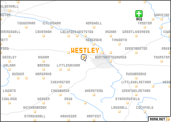
Westley (United Kingdom)Westley is a town in United Kingdom. An overview map of the region around Westley is displayed below.
regional and 3d topo map of Westley, United Kingdom ::
Westley airports ::
The nearest airport is BEQ - Honington, located 12.6 km north east of Westley.
Other airports nearby include MHZ - Mildenhall (17.5 km north west), CBG - Cambridge (34.0 km west), KNF - Marham (45.0 km north), STN - London Stansted (50.3 km south west), Nearby towns ::
Hengrave (3.9km north) //
Fornham All Saints (2.9km north east) //
Risby (2.9km north west) //
Little Saxham (2.9km south west) //
West Stow (5.6km north) //
Bury Saint Edmunds (3.4km east) //
Flempton (5.7km north) //
Great Saxham (3.9km south west) //
Fornham Saint Martin (3.9km north east) //
Lackford (6.0km north) //
Wordwell (7.5km north) //
Whepstead (7.5km south) //
Chevington (6.5km south west) //
Ingham (6.5km north east) //
Timworth (5.9km north east) //
Chedburgh (8.2km south west) //
Icklingham (8.7km north west) //
[all distances 'as the bird flies' and approximate] 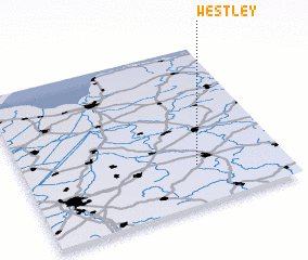 Places with similar names to Westley, United Kingdom ::
Disclaimer :: Information on this page comes without warranty of any kind |
||
|
Where is Westley? Elevation and coordinates ::
Latitude (lat): 52°15'0"N Longitude (lon): 0°40'0"W
Elevation (approx.): 67m (map arrows pan, magnifying glasses zoom) |
||
|
Visiting Westley? Hotel/Accommodation ::
Book a hotel in Westley Travel Guide ::
rental cars ::
car rental offers GPS waypoint ::
download a GPX waypoint (PoI) of Westley for your GPS receiver
|
||