|
search place name
|
||
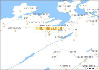
An Craoslach (Donegal, Ireland)An Craoslach is a town in the Donegal region of Ireland. An overview map of the region around An Craoslach is displayed below.
regional and 3d topo map of An Craoslach, Ireland ::
An Craoslach airports ::
The nearest airport is LDY - Londonderry Eglinton, located 47.9 km east of An Craoslach.
Other airports nearby include ENK - Enniskillen St Angelo (81.5 km south), SXL - Sligo (103.4 km south west), BFS - Belfast Aldergrove (119.6 km south east), ILY - Islay (121.7 km north east), Nearby towns ::
Creeslough (0.0km north) //
Masiness (1.5km north west) //
Cashelmore (2.7km north) //
Cashel (2.2km north east) //
Derrylaggy (3.3km south east) //
Ballymore (5.2km north) //
Creevagh (3.9km north east) //
Mullan (3.7km north east) //
Marble Hill (6.4km north) //
Faugher (6.3km north) //
Swillybrin (4.8km north west) //
Portnablagh (7.1km north) //
Port na Bláiche (7.1km north) //
Drum Irish (4.9km north east) //
Drumfin (7.8km south) //
Crockglass (5.4km north west) //
Glenree (6.2km north east) //
Shanbally (6.5km north west) //
Port (7.3km north west) //
Dunfanaghy (8.5km north west) //
Dún Fionnachaidh (8.5km north west) //
Rosapenna (9.2km north east) //
[all distances 'as the bird flies' and approximate]  Places with similar names to An Craoslach, Ireland :: Disclaimer :: Information on this page comes without warranty of any kind |
||
|
Where is An Craoslach? Elevation and coordinates ::
Latitude (lat): 55°7'0"N Longitude (lon): 7°54'0"W
Elevation (approx.): 26m (map arrows pan, magnifying glasses zoom) |
||
|
Visiting An Craoslach? Hotel/Accommodation ::
Book a hotel in An Craoslach Travel Guide ::
Buy a travel guide for Ireland rental cars ::
car rental offers GPS waypoint ::
download a GPX waypoint (PoI) of An Craoslach for your GPS receiver
|
||