|
search place name
|
||
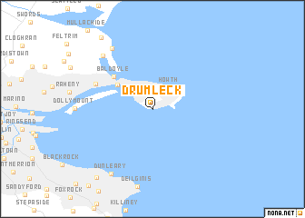
Drumleck (Baile Átha Cliath, Ireland)Drumleck is a town in the Baile Átha Cliath region of Ireland. An overview map of the region around Drumleck is displayed below.
regional and 3d topo map of Drumleck, Ireland ::
nearby GPS traces from timatio ::
Drumleck airports ::
The nearest airport is DUB - Dublin, located 14.0 km north west of Drumleck.
Other airports nearby include IOM - Isle Of Man (125.3 km north east), BHD - Belfast City (140.3 km north), BFS - Belfast Aldergrove (144.3 km north), WAT - Waterford (147.4 km south west), Nearby towns ::
Howth (2.9km north east) //
Binn Éadair (2.9km north east) //
Sutton (4.0km north west) //
Baldoyle (4.9km north west) //
Baile Dúill (4.9km north west) //
Kilbarrack (5.2km north west) //
Saint Marnocks (8.0km north) //
Port Mearnóg (7.5km north west) //
Portmarnock (7.5km north west) //
Dunleary (8.5km south) //
Dún Laoghaire (8.5km south) //
Monkstown (9.3km south west) //
Sea Mount (9.6km north west) //
[all distances 'as the bird flies' and approximate]  Places with similar names to Drumleck, Ireland ::
// Daré Maliki (NE)
// Darmalak (PK)
// Tirmālikh (LB)
// Drimoleague (IE)
// Douar Mouâlek (DZ)
// Tremeleuc (FR)
// Dhrimalaíika (GR)
Disclaimer :: Information on this page comes without warranty of any kind |
||
|
Where is Drumleck? Elevation and coordinates ::
Latitude (lat): 53°21'49"N Longitude (lon): 6°4'58"W
Elevation (approx.): 21m (map arrows pan, magnifying glasses zoom) |
||
|
Visiting Drumleck? Hotel/Accommodation ::
Book a hotel in Drumleck Travel Guide ::
Buy a travel guide for Ireland rental cars ::
car rental offers GPS waypoint ::
download a GPX waypoint (PoI) of Drumleck for your GPS receiver
|
||