|
search place name
|
||
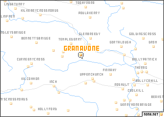
Granavone (Tiobraid Árann, Ireland)Granavone is a town in the Tiobraid Árann region of Ireland. An overview map of the region around Granavone is displayed below.
regional and 3d topo map of Granavone, Ireland ::
Granavone airports ::
The nearest airport is SNN - Shannon, located 60.0 km west of Granavone.
Other airports nearby include GWY - Galway (86.6 km north west), WAT - Waterford (89.6 km south east), ORK - Cork (105.1 km south), KIR - Kerry (118.8 km south west), Nearby towns ::
Currabaha Cross (3.3km north) //
Templederry (3.8km north west) //
Gortnagowna (2.8km west) //
Hunts Grove (3.1km north west) //
Glenbreedy (4.8km north) //
Upperchurch (4.7km south) //
Anglesey Road (5.6km south) //
Cooleenduff Bridge (5.4km south) //
Ballylaine Cross Roads (4.4km north west) //
Finnahy (5.3km south east) //
Inch (7.3km south west) //
Milestone (8.3km south west) //
Gortalough (6.1km north east) //
[all distances 'as the bird flies' and approximate] 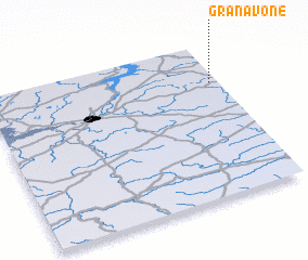 Places with similar names to Granavone, Ireland ::
// Granvin (NO)
// Greenvine (US)
// Kraanven (NL)
// Carnaghan (IE)
// Cornafean (IE)
// Cronavan (IE)
// Garrynafana (IE)
// Kranevenne (BE)
// Koúrnovon (GR)
Disclaimer :: Information on this page comes without warranty of any kind |
||
|
Where is Granavone? Elevation and coordinates ::
Latitude (lat): 52°44'38"N Longitude (lon): 8°2'20"W
Elevation (approx.): 237m (map arrows pan, magnifying glasses zoom) |
||
|
Visiting Granavone? Hotel/Accommodation ::
Book a hotel in Granavone Travel Guide ::
Buy a travel guide for Ireland rental cars ::
car rental offers GPS waypoint ::
download a GPX waypoint (PoI) of Granavone for your GPS receiver
|
||