|
search place name
|
||
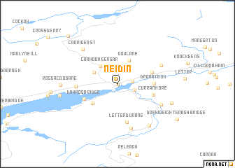
Neidin (Ciarraí, Ireland)Neidin is a town in the Ciarraí region of Ireland. An overview map of the region around Neidin is displayed below.
regional and 3d topo map of Neidin, Ireland ::
Neidin airports ::
The nearest airport is KIR - Kerry, located 33.4 km north of Neidin.
Other airports nearby include ORK - Cork (75.4 km east), SNN - Shannon (101.6 km north east), GWY - Galway (163.6 km north), Nearby towns ::
Kenmare (0.0km north) //
Killowen (1.5km east) //
Sheen Bridge (1.9km south east) //
Carhoomeengar (3.3km north west) //
Gowlane (3.9km north) //
Cappamore (2.9km north west) //
Killaha (3.9km south west) //
Dawros Bridge (4.1km south west) //
Cleady (3.9km north east) //
Dromatouk (3.6km east) //
Curranmore (3.9km south east) //
Letterdunane (6.2km south) //
Reen (4.1km west) //
Releagh Bridge (7.2km south) //
Fustane Lower (5.2km north east) //
Dromanassig Bridge (5.4km south east) //
Carrig East (6.5km north west) //
Banane Bridge (7.3km south east) //
Coolnagoppoge (6.2km south east) //
Derrylea (9.0km north west) //
[all distances 'as the bird flies' and approximate] 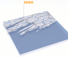 Places with similar names to Neidin, Ireland ::
Disclaimer :: Information on this page comes without warranty of any kind |
||
|
Where is Neidin? Elevation and coordinates ::
Latitude (lat): 51°53'0"N Longitude (lon): 9°35'0"W
Elevation (approx.): 8m (map arrows pan, magnifying glasses zoom) |
||
|
Visiting Neidin? Hotel/Accommodation ::
Book a hotel in Neidin Travel Guide ::
Buy a travel guide for Ireland rental cars ::
car rental offers GPS waypoint ::
download a GPX waypoint (PoI) of Neidin for your GPS receiver
|
||