|
search place name
|
||
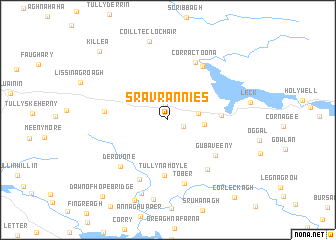
Sravrannies (Leitrim, Ireland)Sravrannies is a town in the Leitrim region of Ireland. An overview map of the region around Sravrannies is displayed below.
regional and 3d topo map of Sravrannies, Ireland ::
Sravrannies airports ::
The nearest airport is ENK - Enniskillen St Angelo, located 27.3 km north east of Sravrannies.
Other airports nearby include SXL - Sligo (37.8 km west), NOC - Connaught (66.6 km south west), LDY - Londonderry Eglinton (101.3 km north east), BFS - Belfast Aldergrove (124.2 km east), Nearby towns ::
Sradrine (1.7km north) //
Meenkeeragh (1.3km south east) //
Glenfarne (2.2km east) //
Brockagh (2.4km east) //
Gortahill (3.5km east) //
Tullynamoyle (6.2km south) //
Gubaveeny (5.0km south east) //
Corractoona (6.6km north) //
Tullyrossmearan (6.4km north) //
Corlea (6.1km south east) //
Briscloonagh (4.2km west) //
Tober (7.1km south) //
Aughrim (6.9km south) //
Dergvone (6.1km south west) //
Ross (8.3km south) //
Kiltyclogher (8.8km north) //
Coillte Clochair (8.8km north) //
Coollegreane (8.9km south) //
Killea (8.8km north west) //
Dawn of Hope Bridge (9.6km south west) //
Corleckagh (9.6km south east) //
[all distances 'as the bird flies' and approximate]  Places with similar names to Sravrannies, Ireland ::
// Sarah Furnace (US)
Disclaimer :: Information on this page comes without warranty of any kind |
||
|
Where is Sravrannies? Elevation and coordinates ::
Latitude (lat): 54°16'48"N Longitude (lon): 8°1'6"W
Elevation (approx.): 94m (map arrows pan, magnifying glasses zoom) |
||
|
Visiting Sravrannies? Hotel/Accommodation ::
Book a hotel in Sravrannies Travel Guide ::
Buy a travel guide for Ireland rental cars ::
car rental offers GPS waypoint ::
download a GPX waypoint (PoI) of Sravrannies for your GPS receiver
|
||