|
search place name
|
||
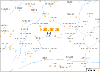
Hum-Varoš (Croatia)Hum-Varoš is a town in Croatia. An overview map of the region around Hum-Varoš is displayed below.
regional and 3d topo map of Hum-Varoš, Croatia ::
Hum-Varoš airports ::
The nearest airport is OSI - Osijek, located 100.6 km east of Hum-Varoš.
Other airports nearby include ZAG - Zagreb (116.7 km west), MBX - Maribor (169.3 km north west), SJJ - Sarajevo (217.0 km south), BUD - Budapest Ferihegy (232.5 km north east), Nearby towns ::
Mačkovac (1.1km west) //
Gornje Kusonje (1.3km east) //
Slana Voda (1.3km east) //
Donje Kusonje (2.9km east) //
Hum (3.5km south west) //
Trnava Cabunska (4.5km north west) //
Budanica (5.6km north) //
Levinovac (3.9km west) //
Popovac Voćinski (5.6km south) //
Cabuna (6.1km north) //
Bistrica (5.3km north east) //
Radosavci (5.2km east) //
Lukavac (5.5km east) //
Žubrica (7.5km north) //
Lisičine (6.8km south west) //
Donji Meljani (6.4km north east) //
Kuzma (9.0km south west) //
Španat (9.0km north east) //
Pčelić (9.7km north west) //
Macute (10.1km south east) //
[all distances 'as the bird flies' and approximate]  Places with similar names to Hum-Varoš, Croatia ::
Disclaimer :: Information on this page comes without warranty of any kind |
||
|
Where is Hum-Varoš? Elevation and coordinates ::
Latitude (lat): 45°42'0"N Longitude (lon): 17°34'0"E
Elevation (approx.): 127m (map arrows pan, magnifying glasses zoom) |
||
|
Visiting Hum-Varoš? Hotel/Accommodation ::
Book a hotel in Hum-Varoš Travel Guide ::
Buy a travel guide for Croatia rental cars ::
car rental offers GPS waypoint ::
download a GPX waypoint (PoI) of Hum-Varoš for your GPS receiver
|
||