|
search place name
|
||
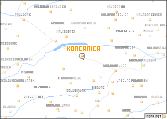
Končanica (Bjelovarsko-Bilogorska Županija, Croatia)Končanica is a town in the Bjelovarsko-Bilogorska Županija region of Croatia. An overview map of the region around Končanica is displayed below.
regional and 3d topo map of Končanica, Croatia ::
Končanica airports ::
The nearest airport is ZAG - Zagreb, located 86.3 km west of Končanica.
Other airports nearby include OSI - Osijek (129.8 km east), MBX - Maribor (148.0 km north west), GRZ - Graz (200.9 km north west), SJJ - Sarajevo (221.5 km south east), Nearby towns ::
Brestovac Daruvarski (3.8km south west) //
Gornji Daruvar (5.0km south) //
Ljudevitno Selo (4.8km south east) //
Ivanovo Polje (5.7km south) //
Mali Zdenci (5.9km north west) //
Grubišno Polje (7.1km north) //
Donji Daruvar (5.6km south east) //
Veliki Zdenci (6.1km north west) //
Donja Rašenica (6.2km north east) //
Šibovac (7.9km south) //
Daruvar (6.8km south east) //
Golubinjak (8.2km south) //
Grbavac (8.1km north west) //
Gornja Rašenica (8.1km north east) //
Doljani (8.9km south east) //
Dežanovac (9.6km south west) //
[all distances 'as the bird flies' and approximate]  Places with similar names to Končanica, Croatia ::
// Quincuncá (BR)
// Canagong (PH)
// Canuog-nuog (PH)
// Concong (PH)
// Conconig (PH)
// Gangngo (PH)
// Kinegnak (US)
// Kinikinik (US)
// Güneykonak (TR)
// Kinniconick (US)
Disclaimer :: Information on this page comes without warranty of any kind |
||
|
Where is Končanica? Elevation and coordinates ::
Latitude (lat): 45°38'10"N Longitude (lon): 17°9'59"E
Elevation (approx.): 152m (map arrows pan, magnifying glasses zoom) |
||
|
Visiting Končanica? Hotel/Accommodation ::
Book a hotel in Končanica Travel Guide ::
Buy a travel guide for Croatia rental cars ::
car rental offers GPS waypoint ::
download a GPX waypoint (PoI) of Končanica for your GPS receiver
|
||