|
search place name
|
||
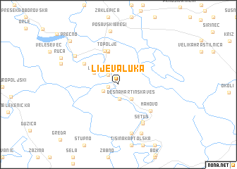
Lijeva Luka (Sisačko-Moslavačka Županija, Croatia)Lijeva Luka is a town in the Sisačko-Moslavačka Županija region of Croatia. An overview map of the region around Lijeva Luka is displayed below.
regional and 3d topo map of Lijeva Luka, Croatia ::
Lijeva Luka airports ::
The nearest airport is ZAG - Zagreb, located 27.8 km north west of Lijeva Luka.
Other airports nearby include MBX - Maribor (110.7 km north west), RJK - Rijeka (146.9 km west), LJU - Ljubliana Ljubljana (163.2 km north west), GRZ - Graz (169.9 km north west), Nearby towns ::
Lijevo Trebarjevo (1.2km west) //
Luka Desna (1.2km west) //
Lijevo Željezno (1.9km north west) //
Lijeva Martinska Ves (2.3km south) //
Desno Trebarjevo (1.9km south west) //
Desna Martinska Ves (2.7km south east) //
Desno Željezno (3.3km north west) //
Desni Dubrovčak (5.3km north) //
Topolje (5.4km north) //
Lijevi Dubravčak (5.6km north) //
Jezero Posavsko (5.0km north west) //
Mahovo (5.4km south east) //
Ljubljanica (6.6km south east) //
Setuš (6.7km south east) //
Žirčica (7.9km south) //
Prerovec (6.6km north west) //
Tišina Erdedska (8.1km south) //
Posavski Bregi (8.5km north) //
Prečno (8.7km north west) //
[all distances 'as the bird flies' and approximate] 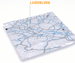 Places with similar names to Lijeva Luka, Croatia :: Disclaimer :: Information on this page comes without warranty of any kind |
||
|
Where is Lijeva Luka? Elevation and coordinates ::
Latitude (lat): 45°36'13"N Longitude (lon): 16°21'54"E
Elevation (approx.): 98m (map arrows pan, magnifying glasses zoom) |
||
|
Visiting Lijeva Luka? Hotel/Accommodation ::
Book a hotel in Lijeva Luka Travel Guide ::
Buy a travel guide for Croatia rental cars ::
car rental offers GPS waypoint ::
download a GPX waypoint (PoI) of Lijeva Luka for your GPS receiver
|
||