|
search place name
|
||
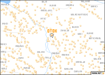
Otok (Croatia)Otok is a town in Croatia. An overview map of the region around Otok is displayed below.
regional and 3d topo map of Otok, Croatia ::
Otok airports ::
The nearest airport is SPU - Split, located 39.4 km south west of Otok.
Other airports nearby include OMO - Mostar (100.4 km south east), ZAD - Zadar (121.0 km north west), SJJ - Sarajevo (129.1 km east), DBV - Dubrovnik (176.8 km south east), Nearby towns ::
Brčići (0.6km north east) //
Katići (0.7km south east) //
Batlan (1.0km north) //
Jelašci (1.1km south) //
Živinići (1.1km north) //
Jukići (1.2km north) //
Ovrlje (1.0km south east) //
Grgetići (1.5km south) //
Milanovići (1.5km north) //
Banići (1.2km west) //
Virić (1.3km south west) //
Vugdelići (1.5km south west) //
Priblače (1.6km south west) //
Kevići (1.8km south west) //
Tadići (1.8km south east) //
Džaja (2.3km south) //
Bilokapići (2.3km south) //
Tomaševići (2.5km north) //
Žuljovići (2.3km south east) //
Gala (2.8km north) //
Munivrane (3.0km north) //
Udovičić (2.9km south) //
Bazići (2.9km south east) //
Vojkovići (3.2km north) //
Svinjača (3.3km south east) //
Matijaševići (3.0km south east) //
Bitunjac (2.8km east) //
Žižića Stražbenica (3.1km east) //
Kulići (3.9km north west) //
[all distances 'as the bird flies' and approximate] 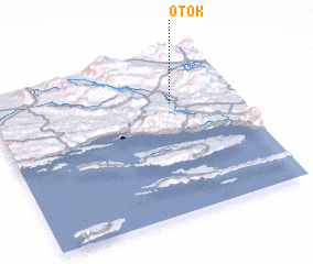 Places with similar names to Otok, Croatia ::
Disclaimer :: Information on this page comes without warranty of any kind |
||
|
Where is Otok? Elevation and coordinates ::
Latitude (lat): 43°41'29"N Longitude (lon): 16°44'18"E
Elevation (approx.): 350m (map arrows pan, magnifying glasses zoom) |
||
|
Visiting Otok? Hotel/Accommodation ::
Book a hotel in Otok Travel Guide ::
Buy a travel guide for Croatia rental cars ::
car rental offers GPS waypoint ::
download a GPX waypoint (PoI) of Otok for your GPS receiver
|
||