|
search place name
|
||
Pocrnja (Croatia)Pocrnja is a town in Croatia. An overview map of the region around Pocrnja is displayed below.
regional and 3d topo map of Pocrnja, Croatia ::

Pocrnja airports ::
The nearest airport is SPU - Split, located 53.8 km west of Pocrnja.
Other airports nearby include OMO - Mostar (79.0 km south east), SJJ - Sarajevo (113.7 km east), ZAD - Zadar (142.3 km north west), DBV - Dubrovnik (155.7 km south east), Nearby towns ::
Lazići (0.6km west) //
Bajlo (0.9km west) //
Pištelek (1.3km north) //
Kotarci (1.5km north east) //
Sablići (1.7km west) //
Miljci (1.7km north east) //
Pervani (1.7km west) //
Gornja Tijarica (1.7km west) //
Marasovići (1.8km west) //
Jukići (1.9km west) //
Dujmići (2.1km north east) //
Aržano (2.0km north east) //
Ljubičići (2.1km east) //
Progon (2.3km north east) //
Bradarići (2.3km north west) //
Marketići (2.9km south) //
Krolo (3.3km north) //
Brdari (3.4km south) //
Donji Tabak (3.4km north) //
Bodrožići (3.5km south) //
Svib (3.6km south) //
Jurčevići (2.7km east) //
Donja Prisika (3.2km north east) //
Čelari (3.7km south) //
Ljubičići (3.2km south east) //
Kamensko (3.8km north) //
Gornji Tabak (3.9km north) //
Brekalo (3.4km north east) //
Matići (4.0km north) //
[all distances 'as the bird flies' and approximate] 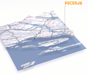 Places with similar names to Pocrnja, Croatia ::
Disclaimer :: Information on this page comes without warranty of any kind |
||
|
Where is Pocrnja? Elevation and coordinates ::
Latitude (lat): 43°35'1"N Longitude (lon): 16°57'40"E
Elevation (approx.): 665m (map arrows pan, magnifying glasses zoom) |
||
|
Visiting Pocrnja? Hotel/Accommodation ::
Book a hotel in Pocrnja Travel Guide ::
Buy a travel guide for Croatia rental cars ::
car rental offers GPS waypoint ::
download a GPX waypoint (PoI) of Pocrnja for your GPS receiver
|
||