|
search place name
|
||
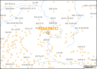
Podunavci (Croatia)Podunavci is a town in Croatia. An overview map of the region around Podunavci is displayed below.
regional and 3d topo map of Podunavci, Croatia ::
Podunavci airports ::
The nearest airport is ZAG - Zagreb, located 56.6 km north of Podunavci.
Other airports nearby include RJK - Rijeka (122.8 km west), ZAD - Zadar (139.9 km south west), MBX - Maribor (142.6 km north), LJU - Ljubliana Ljubljana (170.5 km north west), Nearby towns ::
Gornji Klasnić (0.4km north east) //
Trnovi (0.9km south east) //
Slijepčevići (1.3km north) //
Prusci (1.5km north) //
Bulati (1.4km north west) //
Vladići (1.6km north west) //
Rijeka (1.8km east) //
Samardžije (2.4km north west) //
Januzi (3.0km south) //
Buzeta (2.4km north west) //
Gnjatovići (2.3km west) //
Bogevići (2.5km east) //
Rudići (2.5km east) //
Novak (2.5km west) //
Slatina (3.3km south west) //
Šikanje (3.7km south) //
Dabrina (3.7km north) //
Ličke Kuće (3.5km south west) //
Vilenjak (3.2km south west) //
Kozara (3.4km north east) //
Buzeta (4.0km north west) //
Donji Klasnić (3.3km east) //
Kamešnica (3.4km east) //
Utješenovići (4.8km south) //
Brubno (4.4km south west) //
Brdo (4.8km south west) //
Danguba (5.4km south) //
Radanovići (4.7km south west) //
Maja (5.5km north) //
[all distances 'as the bird flies' and approximate]  Places with similar names to Podunavci, Croatia ::
Disclaimer :: Information on this page comes without warranty of any kind |
||
|
Where is Podunavci? Elevation and coordinates ::
Latitude (lat): 45°14'8"N Longitude (lon): 16°7'59"E
Elevation (approx.): 269m (map arrows pan, magnifying glasses zoom) |
||
|
Visiting Podunavci? Hotel/Accommodation ::
Book a hotel in Podunavci Travel Guide ::
Buy a travel guide for Croatia rental cars ::
car rental offers GPS waypoint ::
download a GPX waypoint (PoI) of Podunavci for your GPS receiver
|
||