|
search place name
|
||
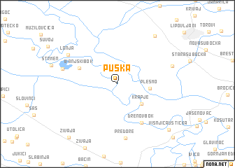
Puska (Sisačko-Moslavačka Županija, Croatia)Puska is a town in the Sisačko-Moslavačka Županija region of Croatia. An overview map of the region around Puska is displayed below.
regional and 3d topo map of Puska, Croatia ::
Puska airports ::
The nearest airport is ZAG - Zagreb, located 73.4 km north west of Puska.
Other airports nearby include MBX - Maribor (154.6 km north west), ZAD - Zadar (177.1 km south west), SPU - Split (202.1 km south), SJJ - Sarajevo (206.5 km south east), Nearby towns ::
Krapje (4.2km south east) //
Plesmo (3.7km east) //
Ivanjski Bok (5.0km north west) //
Drenov Bok (6.8km south east) //
Predore (8.7km south) //
Crkveni Bok (6.6km west) //
Sigetac Novski (6.7km north east) //
Lonja (7.3km north west) //
Kraljeva Velika (8.7km north east) //
Višnjica Ušticka (9.3km south east) //
Živaja (10.2km south west) //
Tanac (10.6km south east) //
[all distances 'as the bird flies' and approximate] 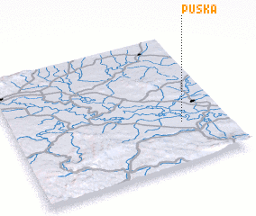 Places with similar names to Puska, Croatia ::
Disclaimer :: Information on this page comes without warranty of any kind |
||
|
Where is Puska? Elevation and coordinates ::
Latitude (lat): 45°19'23"N Longitude (lon): 16°47'36"E
Elevation (approx.): 93m (map arrows pan, magnifying glasses zoom) |
||
|
Visiting Puska? Hotel/Accommodation ::
Book a hotel in Puska Travel Guide ::
Buy a travel guide for Croatia rental cars ::
car rental offers GPS waypoint ::
download a GPX waypoint (PoI) of Puska for your GPS receiver
|
||