|
search place name
|
||
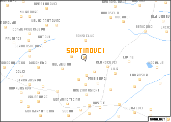
Šaptinovci (Croatia)Šaptinovci is a town in Croatia. An overview map of the region around Šaptinovci is displayed below.
regional and 3d topo map of Šaptinovci, Croatia ::
Šaptinovci airports ::
The nearest airport is OSI - Osijek, located 60.0 km east of Šaptinovci.
Other airports nearby include ZAG - Zagreb (156.2 km west), SJJ - Sarajevo (196.2 km south), BUD - Budapest Ferihegy (226.0 km north east), Nearby towns ::
Teodorovac (2.6km south east) //
Sušine (3.1km south) //
Bokšić (2.4km north west) //
Ðurđenovac (4.1km south) //
Bokšić Lug (4.5km north) //
Klokočevci (3.6km east) //
Ličko Novo Selo (5.2km south) //
Beljevina (3.9km south west) //
Pribiševci (5.2km south) //
Lila (5.3km south east) //
Brezik Našički (7.4km south) //
Velimirovac (7.3km south east) //
Vučjak Feričanački (7.9km south west) //
Kutovi (7.6km north west) //
Mali Rastovac (9.0km north west) //
Veliki Rastovac (9.9km north west) //
Kućanci (10.4km north east) //
[all distances 'as the bird flies' and approximate]  Places with similar names to Šaptinovci, Croatia :: Disclaimer :: Information on this page comes without warranty of any kind |
||
|
Where is Šaptinovci? Elevation and coordinates ::
Latitude (lat): 45°34'45"N Longitude (lon): 18°3'36"E
Elevation (approx.): 98m (map arrows pan, magnifying glasses zoom) |
||
|
Visiting Šaptinovci? Hotel/Accommodation ::
Book a hotel in Šaptinovci Travel Guide ::
Buy a travel guide for Croatia rental cars ::
car rental offers GPS waypoint ::
download a GPX waypoint (PoI) of Šaptinovci for your GPS receiver
|
||