|
search place name
|
||
Veljun (Ličko-Senjska Županija, Croatia)Veljun is a town in the Ličko-Senjska Županija region of Croatia. An overview map of the region around Veljun is displayed below.
regional and 3d topo map of Veljun, Croatia ::

Veljun airports ::
The nearest airport is RJK - Rijeka, located 38.6 km north west of Veljun.
Other airports nearby include PUY - Pula (82.8 km west), ZAD - Zadar (104.4 km south), POW - Portoroz (117.7 km north west), ZAG - Zagreb (119.4 km north east), Nearby towns ::
Francikovac (0.9km west) //
Krivi Put (2.9km north) //
Mrzli Dol (3.4km north east) //
Podbilo (4.3km north) //
Klarićevac (3.5km west) //
Vrataruša (4.4km north west) //
Stubalj (5.0km south east) //
Senj (4.6km south west) //
Kosova Buljina (5.3km north west) //
Vratnik (5.8km south east) //
Grabova Lokva (5.3km north east) //
Županjol (5.2km east) //
Alan (7.3km north) //
Melnice (6.5km south east) //
Stolac (7.8km south) //
Šušanj (7.0km north west) //
Sibinj Krmpotski (7.4km north west) //
Jurjevo (9.1km south) //
Jakovljevići (8.9km south east) //
Bile (8.3km north west) //
Vukelić-Draga (9.5km north west) //
(( Šator )) (9.2km north west) //
[all distances 'as the bird flies' and approximate] 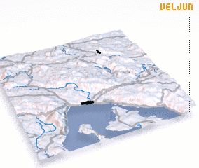 Places with similar names to Veljun, Croatia ::
Disclaimer :: Information on this page comes without warranty of any kind |
||
|
Where is Veljun? Elevation and coordinates ::
Latitude (lat): 45°0'22"N Longitude (lon): 14°57'35"E
Elevation (approx.): 769m (map arrows pan, magnifying glasses zoom) |
||
|
Visiting Veljun? Hotel/Accommodation ::
Book a hotel in Veljun Travel Guide ::
Buy a travel guide for Croatia rental cars ::
car rental offers GPS waypoint ::
download a GPX waypoint (PoI) of Veljun for your GPS receiver
|
||