|
search place name
|
||
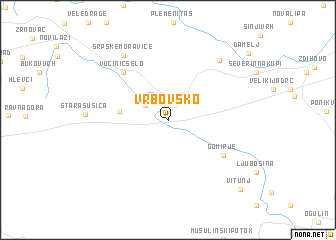
Vrbovsko (Croatia)Vrbovsko is a town in Croatia. An overview map of the region around Vrbovsko is displayed below.
regional and 3d topo map of Vrbovsko, Croatia ::
Vrbovsko airports ::
The nearest airport is RJK - Rijeka, located 43.3 km south west of Vrbovsko.
Other airports nearby include ZAG - Zagreb (87.8 km north east), PUY - Pula (105.2 km south west), LJU - Ljubliana Ljubljana (106.6 km north west), POW - Portoroz (115.1 km west), Nearby towns ::
Senjsko (2.4km north west) //
Jablan (4.0km west) //
Gomirje (5.8km south east) //
Vučinić Selo (6.4km north west) //
Lukovdol (7.7km north east) //
Srpske Moravice (8.0km north west) //
Vitunj (9.5km south east) //
Damelj (9.8km north east) //
[all distances 'as the bird flies' and approximate]  Places with similar names to Vrbovsko, Croatia ::
// Verbovskiy (RU)
// Verbovskiy (RU)
// Verbovskiy (RU)
// Verbovskiy (UA)
// Vrubovskiy (UA)
// Verbovskiy (KZ)
// Vrbovski (CS)
Disclaimer :: Information on this page comes without warranty of any kind |
||
|
Where is Vrbovsko? Elevation and coordinates ::
Latitude (lat): 45°22'7"N Longitude (lon): 15°4'42"E
Elevation (approx.): 440m (map arrows pan, magnifying glasses zoom) |
||
|
Visiting Vrbovsko? Hotel/Accommodation ::
Book a hotel in Vrbovsko Travel Guide ::
Buy a travel guide for Croatia rental cars ::
car rental offers GPS waypoint ::
download a GPX waypoint (PoI) of Vrbovsko for your GPS receiver
|
||