|
search place name
|
||
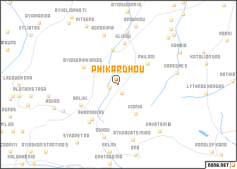
Phikardhou (Cyprus)Phikardhou is a town in Cyprus. An overview map of the region around Phikardhou is displayed below.
regional and 3d topo map of Phikardhou, Cyprus ::
Phikardhou airports ::
The nearest airport is LCA - Larnaca, located 42.6 km east of Phikardhou.
Other airports nearby include AKT - Akrotiri (44.5 km south), PFO - Paphos Pafos Intl (68.3 km south west), Nearby towns ::
Lazania (1.4km south) //
Gourri (1.2km west) //
Kionia (5.2km south east) //
Kalokhorio (5.6km north) //
Philani (5.0km north east) //
Ayios Epiphanios (5.3km north west) //
Klirou (6.5km north) //
Apliki (5.9km south west) //
Pharmakas (6.5km south west) //
Kambi (7.1km south west) //
Agrokipia (8.1km north) //
Malounda (8.4km north) //
Odhou (8.6km south) //
Ayii Vavatsinias (9.0km south) //
Palekhori (8.3km south west) //
Vavatsinia (9.1km south east) //
Politiko (9.8km north east) //
Pera (10.7km north east) //
Episkopion (11.1km north east) //
[all distances 'as the bird flies' and approximate] 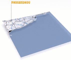 Places with similar names to Phikardhou, Cyprus ::
// Ghogardīha (IN)
Disclaimer :: Information on this page comes without warranty of any kind |
||
|
Where is Phikardhou? Elevation and coordinates ::
Latitude (lat): 34°57'45"N Longitude (lon): 33°10'15"E
Elevation (approx.): 889m (map arrows pan, magnifying glasses zoom) |
||
|
Visiting Phikardhou? Hotel/Accommodation ::
Book a hotel in Phikardhou Travel Guide ::
Buy a travel guide for Cyprus rental cars ::
car rental offers GPS waypoint ::
download a GPX waypoint (PoI) of Phikardhou for your GPS receiver
|
||