|
search place name
|
||
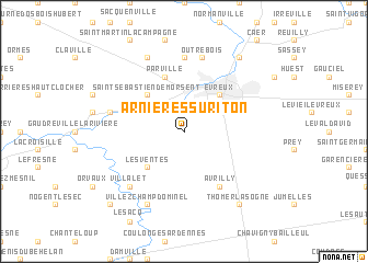
Arnières-sur-Iton (Haute-Normandie, France)Arnières-sur-Iton is a town in the Haute-Normandie region of France. An overview map of the region around Arnières-sur-Iton is displayed below.
regional and 3d topo map of Arnières-sur-Iton, France ::
Arnières-sur-Iton airports ::
The nearest airport is URO - Rouen Vallee De Seine, located 44.8 km north of Arnières-sur-Iton.
Other airports nearby include POX - Pontoise Cormeilles En Vexin (68.7 km east), TNF - Toussous-le-noble Toussus Le Noble (77.0 km east), DOL - Deauville St Gatien (82.0 km north west), BVA - Beauvais Tille (89.5 km north east), Nearby towns ::
Les Ventes (4.4km south west) //
Évreux (4.4km north east) //
Saint-Sébastien-de-Morsent (4.4km north west) //
Parville (5.7km north) //
Le Plessis-Grohan (6.1km south east) //
Avrilly (6.1km south east) //
Aviron (7.4km north) //
Outrebois (7.5km north) //
Aulnay-sur-Iton (5.2km west) //
Villalet (6.7km south west) //
Villez-Champ-Dominel (7.8km south) //
Gauville-la-Campagne (7.8km north) //
Thomer-la-Sôgne (8.3km south east) //
Gravigny (8.3km north east) //
Manthelon (8.9km south west) //
[all distances 'as the bird flies' and approximate] 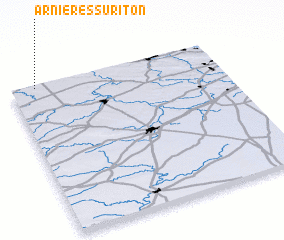 Places with similar names to Arnières-sur-Iton, France :: Disclaimer :: Information on this page comes without warranty of any kind |
||
|
Where is Arnières-sur-Iton? Elevation and coordinates ::
Latitude (lat): 48°59'0"N Longitude (lon): 1°7'0"E
Elevation (approx.): 142m (map arrows pan, magnifying glasses zoom) |
||
|
Visiting Arnières-sur-Iton? Hotel/Accommodation ::
Book a hotel in Arnières-sur-Iton Travel Guide ::
Buy a travel guide for France rental cars ::
car rental offers GPS waypoint ::
download a GPX waypoint (PoI) of Arnières-sur-Iton for your GPS receiver
|
||