|
search place name
|
||
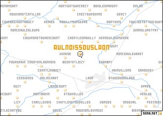
Aulnois-sous-Laon (Picardie, France)Aulnois-sous-Laon is a town in the Picardie region of France. An overview map of the region around Aulnois-sous-Laon is displayed below.
regional and 3d topo map of Aulnois-sous-Laon, France ::
Aulnois-sous-Laon airports ::
The nearest airport is RHE - Reims Champagne, located 47.2 km south east of Aulnois-sous-Laon.
Other airports nearby include CSF - Creil (88.2 km south west), CDG - Paris Charles De Gaulle (101.7 km south west), BVA - Beauvais Tille (109.2 km west), LBG - Paris Le Bourget (110.8 km south west), Nearby towns ::
Besny-et-Loizy (2.2km south west) //
Chéry-lès-Pouilly (3.7km north) //
Vivaise (2.4km west) //
Barenton-Cel (4.4km north east) //
Barenton-Bugny (4.1km north east) //
Chambry (4.1km south east) //
Laon (5.7km south) //
Pouilly-sur-Serre (7.5km north) //
Chalandry (7.8km north) //
Assis-sur-Serre (7.8km north) //
Verneuil-sur-Serre (6.1km north east) //
Clacy-et-Thierret (7.8km south) //
Cerny-lès-Bucy (6.1km south west) //
Molinchart (7.3km south west) //
Laniscourt (8.2km south west) //
Mortiers (8.8km north east) //
Remies (8.8km north west) //
[all distances 'as the bird flies' and approximate]  Places with similar names to Aulnois-sous-Laon, France :: Disclaimer :: Information on this page comes without warranty of any kind |
||
|
Where is Aulnois-sous-Laon? Elevation and coordinates ::
Latitude (lat): 49°37'0"N Longitude (lon): 3°36'0"E
Elevation (approx.): 73m (map arrows pan, magnifying glasses zoom) |
||
|
Visiting Aulnois-sous-Laon? Hotel/Accommodation ::
Book a hotel in Aulnois-sous-Laon Travel Guide ::
Buy a travel guide for France rental cars ::
car rental offers GPS waypoint ::
download a GPX waypoint (PoI) of Aulnois-sous-Laon for your GPS receiver
|
||