|
search place name
|
||
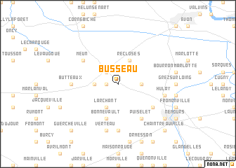
Busseau (Île-de-France, France)Busseau is a town in the Île-de-France region of France. An overview map of the region around Busseau is displayed below.
regional and 3d topo map of Busseau, France ::
Busseau airports ::
The nearest airport is ORY - Paris Orly, located 49.3 km north west of Busseau.
Other airports nearby include TNF - Toussous-le-noble Toussus Le Noble (61.4 km north west), ORE - Orleans Bricy (73.5 km south west), LBG - Paris Le Bourget (73.7 km north), CDG - Paris Charles De Gaulle (77.6 km north), Nearby towns ::
Bessonville (1.2km west) //
Ury (2.2km north west) //
Villiers-sous-Grez (2.5km east) //
La Chapelle-la-Reine (2.5km west) //
Recloses (3.9km north) //
Larchant (3.9km south) //
Bonnevault (5.7km south) //
Puiselet (6.1km south east) //
Achères-la-Forêt (5.2km north west) //
Meun (5.2km north west) //
Foljuif (5.2km south east) //
Chevrainvilliers (7.4km south) //
Butteaux (4.9km west) //
Hulay (5.3km east) //
Verteau (7.5km south) //
Saint-Pierre-lès-Nemours (7.4km south east) //
Chaintreauville (8.9km south east) //
Guercheville (8.9km south west) //
[all distances 'as the bird flies' and approximate] 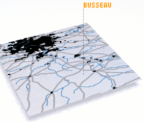 Places with similar names to Busseau, France ::
Disclaimer :: Information on this page comes without warranty of any kind |
||
|
Where is Busseau? Elevation and coordinates ::
Latitude (lat): 48°19'0"N Longitude (lon): 2°37'0"E
Elevation (approx.): 132m (map arrows pan, magnifying glasses zoom) |
||
|
Visiting Busseau? Hotel/Accommodation ::
Book a hotel in Busseau Travel Guide ::
Buy a travel guide for France rental cars ::
car rental offers GPS waypoint ::
download a GPX waypoint (PoI) of Busseau for your GPS receiver
|
||