|
search place name
|
||
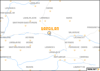
Dargilan (Languedoc-Roussillon, France)Dargilan is a town in the Languedoc-Roussillon region of France. An overview map of the region around Dargilan is displayed below.
regional and 3d topo map of Dargilan, France ::
Dargilan airports ::
The nearest airport is MEN - Mende Brenoux, located 36.1 km north of Dargilan.
Other airports nearby include RDZ - Rodez Marcillac (74.2 km west), MPL - Montpellier Mediterranee (84.3 km south east), OBS - Aubenas-vals-lanas Ardeche Meridionale (88.8 km north east), BZR - Beziers Vias (97.4 km south), Nearby towns ::
Les Mazes (5.6km south) //
La Parade (5.7km north) //
Hyelzas (6.2km north west) //
Lanuéjols (7.5km south) //
Veyreau (5.6km west) //
Meyrueis (6.5km south east) //
Vessac (6.5km south west) //
Hures (7.7km north east) //
La Volpilière (7.7km north west) //
[all distances 'as the bird flies' and approximate] 
Disclaimer :: Information on this page comes without warranty of any kind |
||
|
Where is Dargilan? Elevation and coordinates ::
Latitude (lat): 44°12'0"N Longitude (lon): 3°22'0"E
Elevation (approx.): 698m (map arrows pan, magnifying glasses zoom) |
||
|
Visiting Dargilan? Hotel/Accommodation ::
Book a hotel in Dargilan Travel Guide ::
Buy a travel guide for France rental cars ::
car rental offers GPS waypoint ::
download a GPX waypoint (PoI) of Dargilan for your GPS receiver
|
||