|
search place name
|
||
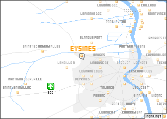
Eysines (Aquitaine, France)Eysines is a town in the Aquitaine region of France. An overview map of the region around Eysines is displayed below.
regional and 3d topo map of Eysines, France ::
Eysines airports ::
The nearest airport is BOD - Bordeaux Merignac, located 8.0 km south west of Eysines.
Other airports nearby include XAC - Arcachon La Teste De Buch (48.5 km south west), RYN - Royan Medis (86.6 km north), CNG - Cognac Chateaubernard (90.0 km north), EGC - Bergerac Roumaniere (92.6 km east), Nearby towns ::
Le Taillan-Médoc (2.3km north west) //
Béchade (3.7km south) //
Bruges (2.6km east) //
Le Haillan (3.2km south west) //
Le Bouscat (3.2km south east) //
Capeyron (3.9km south) //
Le Grand-Louis (3.9km south) //
Blanquefort (3.9km north) //
Caudéran (4.5km south east) //
Veyrines (5.6km south) //
Mérignac (5.7km south) //
Talence (8.4km south east) //
Parempuyre (9.1km north east) //
[all distances 'as the bird flies' and approximate] 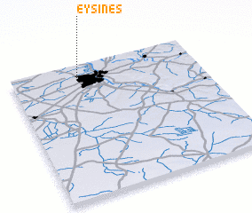 Places with similar names to Eysines, France ::
Disclaimer :: Information on this page comes without warranty of any kind |
||
|
Where is Eysines? Elevation and coordinates ::
Latitude (lat): 44°53'0"N Longitude (lon): 0°39'0"W
Elevation (approx.): 26m (map arrows pan, magnifying glasses zoom) |
||
|
Visiting Eysines? Hotel/Accommodation ::
Book a hotel in Eysines Travel Guide ::
Buy a travel guide for France rental cars ::
car rental offers GPS waypoint ::
download a GPX waypoint (PoI) of Eysines for your GPS receiver
|
||