|
search place name
|
||
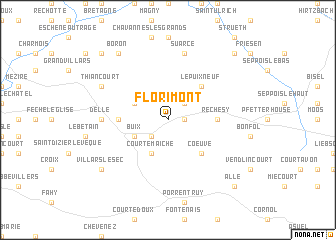
Florimont (Franche-Comté, France)Florimont is a town in the Franche-Comté region of France. An overview map of the region around Florimont is displayed below.
regional and 3d topo map of Florimont, France ::
Florimont airports ::
The nearest airport is MLH - Bale Mulhouse, located 36.3 km east of Florimont.
Other airports nearby include CMR - Colmar Houssen (71.3 km north), BRN - Bern Belp (72.8 km south east), ZRH - Zurich (111.8 km east), EPL - Epinal Mirecourt (118.2 km north west), Nearby towns ::
Courcelles (1.3km east) //
Courtelevant (2.2km north east) //
Montignez (2.2km south west) //
Courtemaîche (3.9km south) //
Buix (3.1km south west) //
Faverois (3.1km north west) //
Lepuix-Neuf (4.5km north east) //
Coeuve (4.5km south east) //
Réchésy (3.8km east) //
Boncourt (3.8km west) //
Delle (5.0km west) //
Suarce (7.5km north) //
Joncherey (6.2km north west) //
Thiancourt (6.2km north west) //
Bure (7.5km south west) //
Villars-le-Sec (7.5km south west) //
Vellescot (8.3km north west) //
Boron (8.3km north west) //
Hindlingen (8.9km north east) //
Alle (8.9km south east) //
Grosne (8.9km north west) //
[all distances 'as the bird flies' and approximate]  Places with similar names to Florimont, France ::
Disclaimer :: Information on this page comes without warranty of any kind |
||
|
Where is Florimont? Elevation and coordinates ::
Latitude (lat): 47°30'0"N Longitude (lon): 7°4'0"E
Elevation (approx.): 422m (map arrows pan, magnifying glasses zoom) |
||
|
Visiting Florimont? Hotel/Accommodation ::
Book a hotel in Florimont Travel Guide ::
Buy a travel guide for France rental cars ::
car rental offers GPS waypoint ::
download a GPX waypoint (PoI) of Florimont for your GPS receiver
|
||