|
search place name
|
||
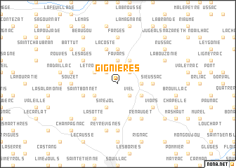
Gignières (Midi-Pyrénées, France)Gignières is a town in the Midi-Pyrénées region of France. An overview map of the region around Gignières is displayed below.
regional and 3d topo map of Gignières, France ::
Gignières airports ::
The nearest airport is BVE - Brive La Roche, located 15.0 km north of Gignières.
Other airports nearby include PGX - Perigueux Bassillac (56.3 km west), AUR - Aurillac (75.4 km east), EGC - Bergerac Roumaniere (79.1 km west), LIG - Limoges Bellegarde (97.0 km north), Nearby towns ::
Estivals (2.3km north west) //
Nayrague (2.3km north east) //
Viel (2.3km south east) //
Favars (3.7km north) //
Le Batut (2.6km east) //
Cressensac (2.6km east) //
Le Troulier (3.2km north west) //
Nespouls (3.9km north) //
Gignac (3.2km south west) //
Siréjol (3.9km south) //
Peyre-Levade (3.2km south east) //
Belveyre (5.6km north) //
Sieussac (3.9km east) //
La Coste (5.7km north) //
Saint-Bonnet (4.3km south west) //
Lacisque (5.7km south) //
Les Ages (5.4km north west) //
Ferrière (5.4km north west) //
La Sotte (6.1km south west) //
Viors (5.4km south east) //
Renaudet (6.1km south east) //
Farges (7.4km north) //
Souzet (5.2km west) //
Les Jouanies (7.4km south) //
Les Sales (5.6km west) //
Reyrevignes (7.5km south) //
Chartrier-Ferrière (6.8km north west) //
La Bouzonie (6.4km north east) //
Beaugou (8.4km north west) //
[all distances 'as the bird flies' and approximate] 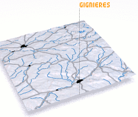 Places with similar names to Gignières, France :: Disclaimer :: Information on this page comes without warranty of any kind |
||
|
Where is Gignières? Elevation and coordinates ::
Latitude (lat): 45°1'0"N Longitude (lon): 1°29'0"E
Elevation (approx.): 296m (map arrows pan, magnifying glasses zoom) |
||
|
Visiting Gignières? Hotel/Accommodation ::
Book a hotel in Gignières Travel Guide ::
Buy a travel guide for France rental cars ::
car rental offers GPS waypoint ::
download a GPX waypoint (PoI) of Gignières for your GPS receiver
|
||