|
search place name
|
||
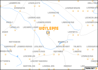
Ivoy-le-Pré (Centre, France)Ivoy-le-Pré is a town in the Centre region of France. An overview map of the region around Ivoy-le-Pré is displayed below.
regional and 3d topo map of Ivoy-le-Pré, France ::
Ivoy-le-Pré airports ::
The nearest airport is BOU - Bourges, located 33.6 km south of Ivoy-le-Pré.
Other airports nearby include NVS - Nevers Fourchambault (61.4 km south east), CHR - Chateauroux Deols (78.8 km south west), ORE - Orleans Bricy (89.3 km north west), AUF - Auxerre Branches (94.4 km north east), Nearby towns ::
Moison (0.0km north) //
La Verrerie (2.2km north east) //
Les Bergerons (3.9km north) //
La Chapelle-dʼAngillon (4.2km north west) //
Boisbelle (5.3km south east) //
Les Loges (6.1km south west) //
Achères (7.5km south) //
Les Naudins (7.5km north) //
Les Thébauts (7.5km south) //
Les Merciers (6.7km north west) //
Henrichemont (6.7km south east) //
La Bréviande (6.2km north east) //
Les Poteries (7.8km south) //
Les Simonneaux (7.8km south) //
Pont-Abbé (7.8km south) //
[all distances 'as the bird flies' and approximate]  Places with similar names to Ivoy-le-Pré, France :: Disclaimer :: Information on this page comes without warranty of any kind |
||
|
Where is Ivoy-le-Pré? Elevation and coordinates ::
Latitude (lat): 47°21'0"N Longitude (lon): 2°29'0"E
Elevation (approx.): 258m (map arrows pan, magnifying glasses zoom) |
||
|
Visiting Ivoy-le-Pré? Hotel/Accommodation ::
Book a hotel in Ivoy-le-Pré Travel Guide ::
Buy a travel guide for France rental cars ::
car rental offers GPS waypoint ::
download a GPX waypoint (PoI) of Ivoy-le-Pré for your GPS receiver
|
||