|
search place name
|
||
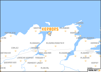
Kerbors (Bretagne, France)Kerbors is a town in the Bretagne region of France. An overview map of the region around Kerbors is displayed below.
regional and 3d topo map of Kerbors, France ::
Kerbors airports ::
The nearest airport is LAI - Lannion, located 22.9 km west of Kerbors.
Other airports nearby include SBK - St.-brieuc Armor Armor (40.8 km south east), MXN - Morlaix Ploujean (53.1 km south west), GCI - Guernsey (79.2 km north east), JER - Jersey (83.4 km north east), Nearby towns ::
Pleumeur-Gautier (3.9km south) //
Saint-Gonery (3.1km north west) //
Trédarzec (5.7km south) //
Plougrescant (4.1km north west) //
Pleubian (4.1km north east) //
Plouguiel (5.2km south west) //
Pouldouran (7.5km south) //
Minihy-Tréguier (6.7km south west) //
Tréguier (6.7km south west) //
Pleudaniel (8.3km south east) //
[all distances 'as the bird flies' and approximate]  Places with similar names to Kerbors, France ::
// Gröbers (DE)
// Kurah Bārāzah (IQ)
// Chroberz (PL)
// Grabarze (PL)
// Grborezi (BA)
// Qurabarāza (IQ)
// Kraboriš (BA)
// Kraboriš (BA)
// Corbreuse (FR)
// Chraberce (CZ)
Disclaimer :: Information on this page comes without warranty of any kind |
||
|
Where is Kerbors? Elevation and coordinates ::
Latitude (lat): 48°50'0"N Longitude (lon): 3°11'0"W
Elevation (approx.): 46m (map arrows pan, magnifying glasses zoom) |
||
|
Visiting Kerbors? Hotel/Accommodation ::
Book a hotel in Kerbors Travel Guide ::
Buy a travel guide for France rental cars ::
car rental offers GPS waypoint ::
download a GPX waypoint (PoI) of Kerbors for your GPS receiver
|
||