|
search place name
|
||
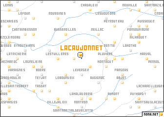
La Caujonnet (Aquitaine, France)La Caujonnet is a town in the Aquitaine region of France. An overview map of the region around La Caujonnet is displayed below.
regional and 3d topo map of La Caujonnet, France ::
La Caujonnet airports ::
The nearest airport is ANG - Angouleme Brie Champniers, located 36.3 km west of La Caujonnet.
Other airports nearby include LIG - Limoges Bellegarde (47.4 km north east), PGX - Perigueux Bassillac (49.8 km south), CNG - Cognac Chateaubernard (76.8 km west), BVE - Brive La Roche (82.6 km south east), Nearby towns ::
Lacaud (1.3km west) //
Piégut-Pluviers (2.3km south east) //
Saint-Estèphe (3.7km south) //
Le Verger (3.7km south) //
Étouars (4.5km south west) //
Les Tuillères (3.9km west) //
Pluviers (3.9km east) //
Montagut (4.3km south east) //
La Parentie (4.3km north east) //
Augignac (6.1km south east) //
Reillac (6.1km north east) //
Le Bourdeix (6.1km south west) //
Busserolles (6.1km north west) //
Lapeyre (5.2km east) //
Bussière-Badil (5.5km west) //
Champniers-et-Reillac (6.4km north east) //
Pys (9.0km south west) //
Peyrouteau (9.0km north east) //
[all distances 'as the bird flies' and approximate]  Places with similar names to La Caujonnet, France ::
// Lacajunte (FR)
// Lạc Giển Tẩu (VN)
Disclaimer :: Information on this page comes without warranty of any kind |
||
|
Where is La Caujonnet? Elevation and coordinates ::
Latitude (lat): 45°38'0"N Longitude (lon): 0°40'0"W
Elevation (approx.): 283m (map arrows pan, magnifying glasses zoom) |
||
|
Visiting La Caujonnet? Hotel/Accommodation ::
Book a hotel in La Caujonnet Travel Guide ::
Buy a travel guide for France rental cars ::
car rental offers GPS waypoint ::
download a GPX waypoint (PoI) of La Caujonnet for your GPS receiver
|
||