|
search place name
|
||
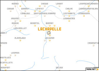
La Chapelle (Rhône-Alpes, France)La Chapelle is a town in the Rhône-Alpes region of France. An overview map of the region around La Chapelle is displayed below.
regional and 3d topo map of La Chapelle, France ::
La Chapelle airports ::
The nearest airport is NCY - Annecy Meythet, located 50.4 km west of La Chapelle.
Other airports nearby include QNJ - Annemasse (53.7 km north west), SIR - Sion (62.9 km north east), GVA - Geneva Cointrin (66.0 km north west), CMF - Chambery Aix Les Bains (69.9 km west), Nearby towns ::
Les Contamines-Montjoie (0.0km north) //
Le Cugnon (1.9km south) //
Saint-Nicolas-de-Véroce (1.9km north) //
Le Baplieu (2.3km south west) //
Bionnay (3.7km north) //
Bionnassay (3.9km north) //
Mémontel (5.4km north west) //
Saint-Gervais-les-Bains (7.5km north) //
Les Houches (7.6km north east) //
Les Chavants (8.4km north east) //
Les Trabets (9.0km north east) //
[all distances 'as the bird flies' and approximate] 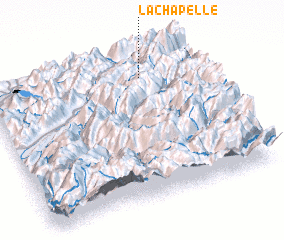 Places with similar names to La Chapelle, France ::
// Lesiopole (PL)
// Law Chapel (US)
// La Chupalla (CL)
// La Chipola (VE)
// La Chipola (VE)
// La Chapelle (GP)
// La Chapelle (HT)
// La Chapelle (HT)
// La Chapelle (HT)
// Lachapelle (FR)
Disclaimer :: Information on this page comes without warranty of any kind |
||
|
Where is La Chapelle? Elevation and coordinates ::
Latitude (lat): 45°50'0"N Longitude (lon): 6°44'0"E
Elevation (approx.): 1216m (map arrows pan, magnifying glasses zoom) |
||
|
Visiting La Chapelle? Hotel/Accommodation ::
Book a hotel in La Chapelle Travel Guide ::
Buy a travel guide for France rental cars ::
car rental offers GPS waypoint ::
download a GPX waypoint (PoI) of La Chapelle for your GPS receiver
|
||