|
search place name
|
||
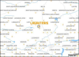
La Gautrais (Bretagne, France)La Gautrais is a town in the Bretagne region of France. An overview map of the region around La Gautrais is displayed below.
regional and 3d topo map of La Gautrais, France ::
La Gautrais airports ::
The nearest airport is RNS - Rennes St Jacques, located 37.7 km west of La Gautrais.
Other airports nearby include LVA - Laval Entrammes (43.3 km south east), DNR - Dinard Pleurtuit (74.1 km north west), LME - Le Mans Arnage (112.9 km east), SNR - St.-nazaire Montoir (118.8 km south west), Nearby towns ::
La Guedonnière (NaNkm north) //
La Mancherie (1.9km north) //
Le Plessis des Fosses (2.2km north west) //
Les Rousselais (2.2km south east) //
Saint-Christophe-des-Bois (3.9km north) //
La Larderie (3.1km north west) //
La Laie dʼIze (3.1km south west) //
Val-dʼIzé (3.1km south west) //
Taillis (3.1km south east) //
Le Rocher (3.1km south east) //
La Cour (3.1km south east) //
Mecé (4.5km north west) //
Landavran (5.7km south) //
Le Verger (5.7km south) //
La Roche Haute (4.1km south east) //
La Roche (4.1km south east) //
Le Bourgneuf (4.1km south west) //
Montreuil-sous-Pérouse (6.1km south east) //
Gazon (7.4km south) //
Saint-Georges-de-Chesné (7.5km north) //
Le Bordage (5.3km east) //
Combourtillé (7.5km north) //
La Roche Basse (5.3km east) //
Gérard (7.5km south) //
Montreuil-des-Landes (6.7km north east) //
Champeaux (6.7km south west) //
Le Rocher Poilanc (6.7km south west) //
Bois Morin (6.2km north east) //
Bois Morin Grand (6.2km north east) //
[all distances 'as the bird flies' and approximate] 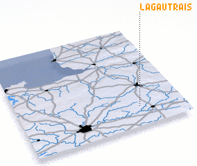 Places with similar names to La Gautrais, France ::
// Lagoa da Rosa (PT)
// Lake Terrace (US)
// Lake Terrace (US)
// Lagoa Atrás (CV)
// La Catorce (DO)
// Lagoa do Arroz (BR)
// Lagoa do Arroz (BR)
// Lagoa do Arroz (BR)
// Lagoa do Arroz (BR)
// La Gautrais (FR)
Disclaimer :: Information on this page comes without warranty of any kind |
||
|
Where is La Gautrais? Elevation and coordinates ::
Latitude (lat): 48°12'0"N Longitude (lon): 1°16'0"W
Elevation (approx.): 117m (map arrows pan, magnifying glasses zoom) |
||
|
Visiting La Gautrais? Hotel/Accommodation ::
Book a hotel in La Gautrais Travel Guide ::
Buy a travel guide for France rental cars ::
car rental offers GPS waypoint ::
download a GPX waypoint (PoI) of La Gautrais for your GPS receiver
|
||