|
search place name
|
||
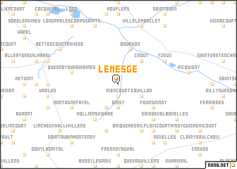
Le Mesge (Picardie, France)Le Mesge is a town in the Picardie region of France. An overview map of the region around Le Mesge is displayed below.
regional and 3d topo map of Le Mesge, France ::
Le Mesge airports ::
The nearest airport is BVA - Beauvais Tille, located 53.5 km south of Le Mesge.
Other airports nearby include LTQ - Le Tourquet Le Touquet Paris Plage (71.8 km north west), CSF - Creil (82.9 km south east), URO - Rouen Vallee De Seine (87.9 km south west), POX - Pontoise Cormeilles En Vexin (93.1 km south), Nearby towns ::
Riencourt (1.9km south) //
Soues (1.9km north) //
Oissy (3.7km south) //
Cavillon (3.0km south east) //
Dreuil-lès-Molliens (3.9km south) //
Crouy (4.4km north east) //
Hangest-sur-Somme (5.7km north) //
Bourdon (5.7km north) //
Fourdrinoy (5.2km south east) //
Molliens-Vidame (6.1km south west) //
Bougainville (7.5km south) //
Quesnoy-sur-Airaines (5.1km west) //
Saisseval (6.6km south east) //
Briquemesnil-Floxicourt (7.8km south) //
Montagne-Fayel (6.0km south west) //
Yzeux (6.0km north east) //
Seux (8.2km south east) //
[all distances 'as the bird flies' and approximate] 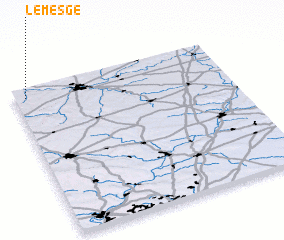
Disclaimer :: Information on this page comes without warranty of any kind |
||
|
Where is Le Mesge? Elevation and coordinates ::
Latitude (lat): 49°56'0"N Longitude (lon): 2°3'0"E
Elevation (approx.): 38m (map arrows pan, magnifying glasses zoom) |
||
|
Visiting Le Mesge? Hotel/Accommodation ::
Book a hotel in Le Mesge Travel Guide ::
Buy a travel guide for France rental cars ::
car rental offers GPS waypoint ::
download a GPX waypoint (PoI) of Le Mesge for your GPS receiver
|
||