|
search place name
|
||
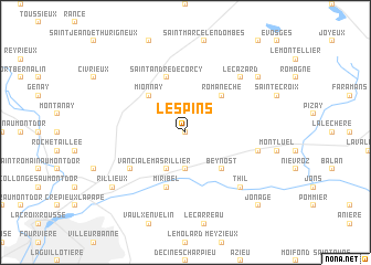
Les Pins (Rhône-Alpes, France)Les Pins is a town in the Rhône-Alpes region of France. An overview map of the region around Les Pins is displayed below.
regional and 3d topo map of Les Pins, France ::
Les Pins airports ::
The nearest airport is LYN - Lyon Bron, located 15.6 km south of Les Pins.
Other airports nearby include LYS - Lyon Saint Exupery (18.3 km south east), XVF - Vilefrance Tarare (26.0 km west), XBK - Bourg Ceyzeriat (44.9 km north east), QNX - Macon Charnay (49.4 km north), Nearby towns ::
Tramoyes (0.0km north) //
Saint-Maurice-de-Beynost (3.7km south) //
Le Mas Rillier (3.9km south) //
Romanèche (4.5km north east) //
Mionnay (4.5km north west) //
Le Grand Peuplier (4.5km south east) //
Beynost (4.5km south east) //
Saint-André-de-Corcy (5.7km north) //
Miribel (5.7km south) //
Vancia (5.4km south west) //
La Boisse (5.5km east) //
Le Cazard (6.8km north east) //
Thil (6.8km south east) //
Cordieux (7.6km north east) //
Rillieux (7.6km south west) //
Jonage (9.0km south east) //
[all distances 'as the bird flies' and approximate]  Places with similar names to Les Pins, France ::
Disclaimer :: Information on this page comes without warranty of any kind |
||
|
Where is Les Pins? Elevation and coordinates ::
Latitude (lat): 45°52'0"N Longitude (lon): 4°58'0"E
Elevation (approx.): 300m (map arrows pan, magnifying glasses zoom) |
||
|
Visiting Les Pins? Hotel/Accommodation ::
Book a hotel in Les Pins Travel Guide ::
Buy a travel guide for France rental cars ::
car rental offers GPS waypoint ::
download a GPX waypoint (PoI) of Les Pins for your GPS receiver
|
||