|
search place name
|
||
Les Routis (Picardie, France)Les Routis is a town in the Picardie region of France. An overview map of the region around Les Routis is displayed below.
regional and 3d topo map of Les Routis, France ::

Les Routis airports ::
The nearest airport is BVA - Beauvais Tille, located 21.2 km east of Les Routis.
Other airports nearby include POX - Pontoise Cormeilles En Vexin (37.0 km south east), URO - Rouen Vallee De Seine (47.8 km west), CSF - Creil (52.4 km east), LBG - Paris Le Bourget (65.3 km south east), Nearby towns ::
Le Coudray-Saint-Germer (1.9km north) //
Lincourt (3.7km south) //
Cuigy-en-Bray (3.7km north) //
La Grande Cour (3.9km south) //
Espaubourg (4.4km north east) //
La Tremblée (5.6km south) //
La Petite Landelle (3.6km east) //
Lalandelle (3.6km east) //
Les Solons (5.6km north) //
Flavacourt (5.7km south) //
Guillenfosse (5.7km north) //
Les Maisonnettes (5.7km south) //
Lalande-en-Son (4.1km south west) //
Puiseux-en-Bray (4.1km north west) //
Les Eaux-Ouies (5.7km north) //
La Fonderie (5.2km south east) //
Bourguerelle (5.2km south west) //
Saint-Aubin-en-Bray (5.2km north east) //
Le Vaumain (6.1km south east) //
Les Clos (6.1km north east) //
Le But-David (4.8km west) //
Boutencourt (7.5km south) //
Montreuil (7.5km north) //
Saint-Germer-de-Fly (6.6km north west) //
Montcornet (6.1km south east) //
Blacourt (7.8km north) //
Sérifontaine (7.4km south west) //
Labosse (7.4km south east) //
La Haute Rue (8.2km north east) //
[all distances 'as the bird flies' and approximate] 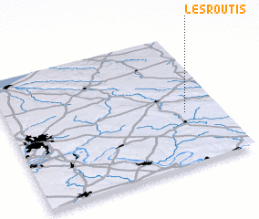 Places with similar names to Les Routis, France ::
// Los Cerritos (US)
// Los Cerritos (PA)
// Los Cerritos (PA)
// Los Cerritos (PA)
// Los Cerritos (PA)
// Los Cerritos (PA)
// Los Cerritos (PA)
// Los Cerritos (PA)
// Los Cerritos (PA)
// Los Cerritos (PA)
Disclaimer :: Information on this page comes without warranty of any kind |
||
|
Where is Les Routis? Elevation and coordinates ::
Latitude (lat): 49°24'0"N Longitude (lon): 1°50'0"E
Elevation (approx.): 215m (map arrows pan, magnifying glasses zoom) |
||
|
Visiting Les Routis? Hotel/Accommodation ::
Book a hotel in Les Routis Travel Guide ::
Buy a travel guide for France rental cars ::
car rental offers GPS waypoint ::
download a GPX waypoint (PoI) of Les Routis for your GPS receiver
|
||