|
search place name
|
||
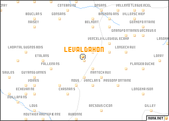
Le Valdahon (Franche-Comté, France)Le Valdahon is a town in the Franche-Comté region of France. An overview map of the region around Le Valdahon is displayed below.
regional and 3d topo map of Le Valdahon, France ::
Le Valdahon airports ::
The nearest airport is DLE - Dole Tavaux, located 71.1 km west of Le Valdahon.
Other airports nearby include BRN - Bern Belp (91.1 km east), DIJ - Dijon Longvic (96.4 km west), MLH - Bale Mulhouse (101.6 km north east), GVA - Geneva Cointrin (103.0 km south), Nearby towns ::
Le Valdahon-du-Haut (0.0km north) //
Le Valdahon-du-Bas (0.0km north) //
Chevigney (2.2km north east) //
Épenoy (2.2km south east) //
Étray (3.7km south) //
Rantechaux (4.5km south east) //
Nods (5.7km south) //
Vanclans (5.7km south) //
Adam-lès-Vercel (4.2km north east) //
Vercel-Villedieu-le-Camp (5.3km north east) //
Belmont (7.5km north) //
Fallerans (5.4km west) //
Vernierfontaine (6.7km south west) //
Chasnans (7.8km south) //
Athose (7.8km south) //
Passonfontaine (7.5km south east) //
Épenouse (8.3km north east) //
[all distances 'as the bird flies' and approximate] 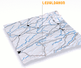 Places with similar names to Le Valdahon, France :: Disclaimer :: Information on this page comes without warranty of any kind |
||
|
Where is Le Valdahon? Elevation and coordinates ::
Latitude (lat): 47°9'0"N Longitude (lon): 6°21'0"E
Elevation (approx.): 665m (map arrows pan, magnifying glasses zoom) |
||
|
Visiting Le Valdahon? Hotel/Accommodation ::
Book a hotel in Le Valdahon Travel Guide ::
Buy a travel guide for France rental cars ::
car rental offers GPS waypoint ::
download a GPX waypoint (PoI) of Le Valdahon for your GPS receiver
|
||