|
search place name
|
||
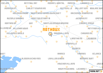
Mathaux (Champagne-Ardenne, France)Mathaux is a town in the Champagne-Ardenne region of France. An overview map of the region around Mathaux is displayed below.
regional and 3d topo map of Mathaux, France ::
Mathaux airports ::
The nearest airport is QYR - Troyes Barberey, located 34.9 km west of Mathaux.
Other airports nearby include AUF - Auxerre Branches (93.2 km south west), RHE - Reims Champagne (109.6 km north), EPL - Epinal Mirecourt (117.7 km east), DIJ - Dijon Longvic (130.2 km south), Nearby towns ::
LʼÉtape (2.2km south west) //
Chantemerle (2.2km south east) //
Radonvilliers (2.5km east) //
Épagne (3.9km north) //
Blaincourt-sur-Aube (3.1km north west) //
Saint-Léger-sous-Brienne (3.9km north) //
Brienne-la-Vieille (3.7km east) //
Dienville (4.1km south east) //
Brienne-le-Château (5.2km north east) //
Précy-Saint-Martin (6.1km north west) //
Saint-Christophe-Dodinicourt (7.5km north) //
Précy-Notre-Dame (6.7km north west) //
Pel-et-Der (6.2km north west) //
Der (6.2km north west) //
Unienville (6.2km south east) //
Amance (7.8km south) //
Perthes-lès-Brienne (8.3km north east) //
Lesmont (8.9km north west) //
[all distances 'as the bird flies' and approximate]  Places with similar names to Mathaux, France ::
// Mathieux (HT)
Disclaimer :: Information on this page comes without warranty of any kind |
||
|
Where is Mathaux? Elevation and coordinates ::
Latitude (lat): 48°22'0"N Longitude (lon): 4°29'0"E
Elevation (approx.): 128m (map arrows pan, magnifying glasses zoom) |
||
|
Visiting Mathaux? Hotel/Accommodation ::
Book a hotel in Mathaux Travel Guide ::
Buy a travel guide for France rental cars ::
car rental offers GPS waypoint ::
download a GPX waypoint (PoI) of Mathaux for your GPS receiver
|
||