|
search place name
|
||
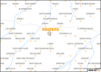
Maurens (Midi-Pyrénées, France)Maurens is a town in the Midi-Pyrénées region of France. An overview map of the region around Maurens is displayed below.
regional and 3d topo map of Maurens, France ::
Maurens airports ::
The nearest airport is LRH - La Rochelle Lherm, located 33.8 km south east of Maurens.
Other airports nearby include TLS - Toulouse Blagnac (37.6 km east), AGF - Agen La Garenne (68.5 km north), LDE - Tarbes Lourdes (87.1 km south west), LBI - Albi Le Sequestre (103.7 km east), Nearby towns ::
Giscaro (2.3km north east) //
Lahas (3.7km south) //
Gimont (3.9km north) //
Garbic (4.6km north east) //
Escorneboeuf (5.6km north) //
Frégouville (4.0km east) //
Bézéril (5.6km south) //
Montiron (4.4km south west) //
Saint-André (6.2km south west) //
Juilles (5.4km west) //
Sainte-Marie (7.5km north) //
Aurimont (5.7km west) //
Noilhan (7.9km south) //
Catonvielle (7.7km north east) //
Saint-Germier (8.4km north east) //
Polastron (8.4km south west) //
Cazaux-Savès (9.2km south east) //
[all distances 'as the bird flies' and approximate] 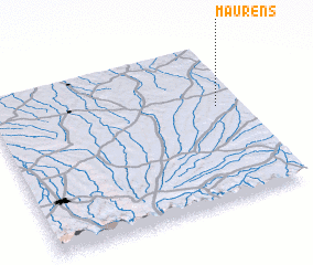 Places with similar names to Maurens, France ::
Disclaimer :: Information on this page comes without warranty of any kind |
||
|
Where is Maurens? Elevation and coordinates ::
Latitude (lat): 43°36'0"N Longitude (lon): 0°54'0"W
Elevation (approx.): 184m (map arrows pan, magnifying glasses zoom) |
||
|
Visiting Maurens? Hotel/Accommodation ::
Book a hotel in Maurens Travel Guide ::
Buy a travel guide for France rental cars ::
car rental offers GPS waypoint ::
download a GPX waypoint (PoI) of Maurens for your GPS receiver
|
||