|
search place name
|
||
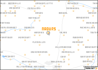
Naours (Picardie, France)Naours is a town in the Picardie region of France. An overview map of the region around Naours is displayed below.
regional and 3d topo map of Naours, France ::
Naours airports ::
The nearest airport is BVA - Beauvais Tille, located 65.5 km south of Naours.
Other airports nearby include LTQ - Le Tourquet Le Touquet Paris Plage (71.6 km north west), LIL - Lille Lesquin (82.2 km north east), CSF - Creil (88.4 km south), POX - Pontoise Cormeilles En Vexin (105.6 km south), Nearby towns ::
Wargnies (2.4km west) //
La Vicogne (3.0km north east) //
Flesselles (4.4km south west) //
Havernas (3.6km west) //
Talmas (3.6km east) //
Bonneville (6.0km north west) //
Bertangles (7.4km south) //
Canaples (5.1km west) //
Montrelet (6.6km north west) //
Fieffes (6.6km north west) //
Villers-Bocage (6.6km south east) //
Vaux-en-Amiénois (7.8km south) //
Candas (7.8km north) //
Beauval (8.2km north east) //
Rainneville (8.8km south east) //
[all distances 'as the bird flies' and approximate] 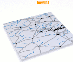 Places with similar names to Naours, France ::
Disclaimer :: Information on this page comes without warranty of any kind |
||
|
Where is Naours? Elevation and coordinates ::
Latitude (lat): 50°2'0"N Longitude (lon): 2°17'0"E
Elevation (approx.): 86m (map arrows pan, magnifying glasses zoom) |
||
|
Visiting Naours? Hotel/Accommodation ::
Book a hotel in Naours Travel Guide ::
Buy a travel guide for France rental cars ::
car rental offers GPS waypoint ::
download a GPX waypoint (PoI) of Naours for your GPS receiver
|
||