|
search place name
|
||
Ornon (Rhône-Alpes, France)Ornon is a town in the Rhône-Alpes region of France. An overview map of the region around Ornon is displayed below.
regional and 3d topo map of Ornon, France ::

Ornon airports ::
The nearest airport is GNB - Grenoble Saint Geoirs, located 62.0 km north west of Ornon.
Other airports nearby include CMF - Chambery Aix Les Bains (65.9 km north), VAF - Valence Chabeuil (81.2 km west), NCY - Annecy Meythet (98.1 km north), LYS - Lyon Saint Exupery (102.6 km north west), Nearby towns ::
La Poutuire (1.9km south) //
Oulles (3.7km north) //
Villard-Reymond (3.2km south east) //
La Paute (4.5km north east) //
Le Bourg-dʼOisans (3.9km east) //
Le Vert (4.3km south east) //
La Garde (4.3km north east) //
Armentier Haut (5.2km east) //
Les Sciauds (7.5km south) //
Villelonge (7.5km south) //
Les Bosses (7.5km south) //
Grandes Sables (7.5km north) //
Livet-et-Gavet (6.8km north west) //
Villard-Reculas (6.8km north east) //
Villard-Notre-Dame (6.4km south east) //
Huez (6.4km north east) //
Miribel (7.9km north) //
Sardonne (9.1km north east) //
[all distances 'as the bird flies' and approximate] 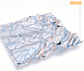 Places with similar names to Ornon, France ::
Disclaimer :: Information on this page comes without warranty of any kind |
||
|
Where is Ornon? Elevation and coordinates ::
Latitude (lat): 45°3'0"N Longitude (lon): 5°59'0"E
Elevation (approx.): 1031m (map arrows pan, magnifying glasses zoom) |
||
|
Visiting Ornon? Hotel/Accommodation ::
Book a hotel in Ornon Travel Guide ::
Buy a travel guide for France rental cars ::
car rental offers GPS waypoint ::
download a GPX waypoint (PoI) of Ornon for your GPS receiver
|
||