|
search place name
|
||
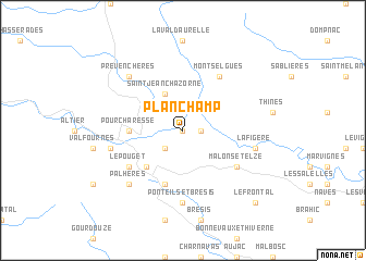
Planchamp (Languedoc-Roussillon, France)Planchamp is a town in the Languedoc-Roussillon region of France. An overview map of the region around Planchamp is displayed below.
regional and 3d topo map of Planchamp, France ::
Planchamp airports ::
The nearest airport is OBS - Aubenas-vals-lanas Ardeche Meridionale, located 33.4 km east of Planchamp.
Other airports nearby include MEN - Mende Brenoux (34.7 km west), LPY - Le Puy Loudes (70.1 km north), FNI - Nimes Garons (86.6 km south east), VAF - Valence Chabeuil (94.2 km north east), Nearby towns ::
Faugères (0.0km north) //
Sainte-Marguerite-Lafigère (1.3km east) //
Les Balmelles (2.3km south west) //
Saint-Jean-Chazorne (3.9km north) //
Villefort (4.6km south west) //
Pourcharesse (4.0km west) //
Saint-André-Capcèze (5.7km south) //
Montselgues (6.2km north east) //
Malons-et-Elze (5.4km south east) //
Le Pouget (5.4km south west) //
Ponteils-et-Brésis (7.4km south) //
Lafigère (5.6km east) //
Combret (5.6km west) //
Palhères (6.8km south west) //
Prévenchères (6.8km north west) //
Le Frontal (9.1km south east) //
[all distances 'as the bird flies' and approximate] 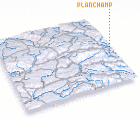 Places with similar names to Planchamp, France :: Disclaimer :: Information on this page comes without warranty of any kind |
||
|
Where is Planchamp? Elevation and coordinates ::
Latitude (lat): 44°28'0"N Longitude (lon): 3°58'0"E
Elevation (approx.): 531m (map arrows pan, magnifying glasses zoom) |
||
|
Visiting Planchamp? Hotel/Accommodation ::
Book a hotel in Planchamp Travel Guide ::
Buy a travel guide for France rental cars ::
car rental offers GPS waypoint ::
download a GPX waypoint (PoI) of Planchamp for your GPS receiver
|
||