|
search place name
|
||
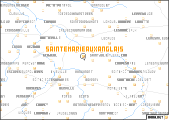
Sainte-Marie-aux-Anglais (Basse-Normandie, France)Sainte-Marie-aux-Anglais is a town in the Basse-Normandie region of France. An overview map of the region around Sainte-Marie-aux-Anglais is displayed below.
regional and 3d topo map of Sainte-Marie-aux-Anglais, France ::
Sainte-Marie-aux-Anglais airports ::
The nearest airport is DOL - Deauville St Gatien, located 34.4 km north of Sainte-Marie-aux-Anglais.
Other airports nearby include CFR - Caen Carpiquet (37.2 km west), LEH - Le Havre Octeville (52.1 km north), URO - Rouen Vallee De Seine (90.3 km north east), LME - Le Mans Arnage (124.9 km south), Nearby towns ::
Les Authieux-Papion (1.2km east) //
Le Mesnil-Mauger (2.2km north west) //
Saint-Crespin (2.2km north east) //
Vieux-Pont (3.7km south) //
Grandchamp-Le-Château (3.1km north east) //
Mittois (5.6km south) //
Saint-Julien-le-Faucon (3.6km east) //
Saint-Loup-de-Fribois (5.7km north) //
Crèvecoeur-en-Auge (5.7km north) //
Boissey (5.7km south) //
Ouville-la-Bien-Tournée (4.1km south west) //
Notre-Dame-de-Livaye (5.7km north) //
Monteille (5.7km north) //
Lécaude (5.2km north east) //
Castillon-en-Auge (5.2km south east) //
Bretteville-sur-Dives (5.2km south west) //
Thiéville (5.2km south west) //
Saint-Pair-du-Mont (7.4km north) //
Saint-Laurent-du-Mont (7.4km north) //
Écajeul (4.9km west) //
Le Mesnil-Simon (5.2km east) //
Sainte-Marguerite-de-Viette (6.6km south east) //
Hiéville (6.6km south west) //
Quétiéville (6.1km north west) //
Berville (7.8km south) //
Saint-Aubin-sur-Algot (8.3km north east) //
Saint-Pierre-sur-Dives (7.4km south west) //
Biéville-en-Auge (8.9km north west) //
Corbon (8.9km north west) //
[all distances 'as the bird flies' and approximate]  Places with similar names to Sainte-Marie-aux-Anglais, France :: Disclaimer :: Information on this page comes without warranty of any kind |
||
|
Where is Sainte-Marie-aux-Anglais? Elevation and coordinates ::
Latitude (lat): 49°4'0"N Longitude (lon): 0°2'0"W
Elevation (approx.): 34m (map arrows pan, magnifying glasses zoom) |
||
|
Visiting Sainte-Marie-aux-Anglais? Hotel/Accommodation ::
Book a hotel in Sainte-Marie-aux-Anglais Travel Guide ::
Buy a travel guide for France rental cars ::
car rental offers GPS waypoint ::
download a GPX waypoint (PoI) of Sainte-Marie-aux-Anglais for your GPS receiver
|
||