|
search place name
|
||
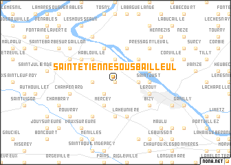
Saint-Étienne-sous-Bailleul (Haute-Normandie, France)Saint-Étienne-sous-Bailleul is a town in the Haute-Normandie region of France. An overview map of the region around Saint-Étienne-sous-Bailleul is displayed below.
regional and 3d topo map of Saint-Étienne-sous-Bailleul, France ::
Saint-Étienne-sous-Bailleul airports ::
The nearest airport is URO - Rouen Vallee De Seine, located 34.0 km north west of Saint-Étienne-sous-Bailleul.
Other airports nearby include POX - Pontoise Cormeilles En Vexin (46.8 km east), BVA - Beauvais Tille (64.0 km north east), TNF - Toussous-le-noble Toussus Le Noble (65.7 km south east), LBG - Paris Le Bourget (77.9 km east), Nearby towns ::
Saint-Pierre-de-Bailleul (0.0km north) //
La Chapelle-Réanville (2.2km south west) //
Saint-Pierre-la-Garenne (3.7km north) //
Saint-Pierre-dʼAutils (2.4km east) //
Villez-sous-Bailleul (2.4km west) //
Mercey (3.9km south) //
Couvicourt (4.4km north west) //
Notre-Dame-de-lʼIsle (4.4km north east) //
Habloville (4.4km north west) //
Saint-Just (3.6km east) //
Saint-Vincent-des-Bois (5.6km south) //
Pressagny-lʼOrgeuilleux (4.1km north east) //
Notre-Dame-de-la-Garenne (5.7km north) //
Port-Mort (5.7km north) //
Le Rouy (4.1km south east) //
Saint-Marcel (4.1km south east) //
La Heunière (5.7km south) //
Gailloncel (5.2km north west) //
Houlbec-Cocherel (6.1km south west) //
Bizy (5.2km south east) //
Sainte-Colombe-près-Vernon (5.2km west) //
Champenard (5.2km west) //
Pressagny-le-Val (6.6km north east) //
Courcelles-sur-Seine (7.8km north) //
Aubevoye (6.1km north west) //
Saint-Aubin-sur-Gaillon (6.1km north west) //
Gaillon (7.4km north west) //
Rouvray (7.4km south west) //
Vaux-sur-Eure (8.3km south west) //
[all distances 'as the bird flies' and approximate]  Places with similar names to Saint-Étienne-sous-Bailleul, France :: Disclaimer :: Information on this page comes without warranty of any kind |
||
|
Where is Saint-Étienne-sous-Bailleul? Elevation and coordinates ::
Latitude (lat): 49°7'0"N Longitude (lon): 1°24'0"E
Elevation (approx.): 101m (map arrows pan, magnifying glasses zoom) |
||
|
Visiting Saint-Étienne-sous-Bailleul? Hotel/Accommodation ::
Book a hotel in Saint-Étienne-sous-Bailleul Travel Guide ::
Buy a travel guide for France rental cars ::
car rental offers GPS waypoint ::
download a GPX waypoint (PoI) of Saint-Étienne-sous-Bailleul for your GPS receiver
|
||