|
search place name
|
||
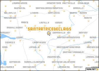
Saint-Patrice-de-Claids (Basse-Normandie, France)Saint-Patrice-de-Claids is a town in the Basse-Normandie region of France. An overview map of the region around Saint-Patrice-de-Claids is displayed below.
regional and 3d topo map of Saint-Patrice-de-Claids, France ::
Saint-Patrice-de-Claids airports ::
The nearest airport is CER - Cherbourg Maupertus, located 46.4 km north of Saint-Patrice-de-Claids.
Other airports nearby include JER - Jersey (55.6 km west), CFR - Caen Carpiquet (72.0 km east), ACI - Alderney (77.3 km north west), DNR - Dinard Pleurtuit (86.0 km south west), Nearby towns ::
Gonfreville (2.4km east) //
Laulne (3.0km north west) //
Lastelle (3.9km north) //
La Martinerie (4.4km south west) //
Gorges (4.4km north east) //
Périers (5.7km south) //
Millières (6.1km south west) //
Gerville-la-Forêt (5.2km north west) //
Nay (4.8km east) //
Saint-Germain-sur-Sèves (5.2km east) //
Saint-Jores (7.5km north) //
Vesly (5.2km west) //
La Feuillie (6.6km south west) //
Saint-Sébastien-de-Raids (7.4km south east) //
Lithaire (8.3km north west) //
[all distances 'as the bird flies' and approximate] 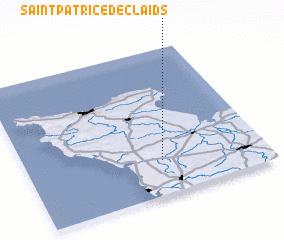 Places with similar names to Saint-Patrice-de-Claids, France :: Disclaimer :: Information on this page comes without warranty of any kind |
||
|
Where is Saint-Patrice-de-Claids? Elevation and coordinates ::
Latitude (lat): 49°14'0"N Longitude (lon): 1°26'0"W
Elevation (approx.): 31m (map arrows pan, magnifying glasses zoom) |
||
|
Visiting Saint-Patrice-de-Claids? Hotel/Accommodation ::
Book a hotel in Saint-Patrice-de-Claids Travel Guide ::
Buy a travel guide for France rental cars ::
car rental offers GPS waypoint ::
download a GPX waypoint (PoI) of Saint-Patrice-de-Claids for your GPS receiver
|
||