|
search place name
|
||
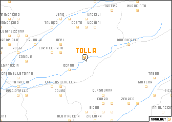
Tolla (France)Tolla is a town in France. An overview map of the region around Tolla is displayed below.
regional and 3d topo map of Tolla, France ::
Tolla airports ::
The nearest airport is AJA - Ajaccio Campo Dell Oro, located 14.4 km west of Tolla.
Other airports nearby include SOZ - Solenzara (36.7 km east), FSC - Figari Sud Corse (52.9 km south), CLY - Calvi Saint Catherine (64.3 km north), BIA - Bastia Poretta (77.8 km north east), Nearby towns ::
Ocana (3.3km south west) //
Cutoli-Corticchiato (4.5km north west) //
Olmo (5.6km north west) //
Peri (5.6km north west) //
Crucoli (7.4km north) //
Ucciani (7.5km north) //
Carbuccia (7.5km north) //
Costa (7.5km north) //
Corticchiato (5.8km west) //
Eccica-Suerella (6.9km south west) //
Bodiciasche (6.9km south west) //
Quasquara (7.9km south) //
Barracone (7.8km south west) //
Cauro (8.5km south west) //
Tavaco (9.2km north west) //
Prati (9.2km north west) //
[all distances 'as the bird flies' and approximate] 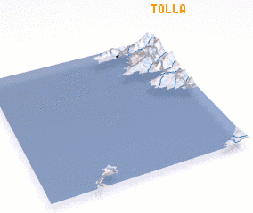 Places with similar names to Tolla, France ::
Disclaimer :: Information on this page comes without warranty of any kind |
||
|
Where is Tolla? Elevation and coordinates ::
Latitude (lat): 41°58'0"N Longitude (lon): 8°58'0"E
Elevation (approx.): 556m (map arrows pan, magnifying glasses zoom) |
||
|
Visiting Tolla? Hotel/Accommodation ::
Book a hotel in Tolla Travel Guide ::
Buy a travel guide for France rental cars ::
car rental offers GPS waypoint ::
download a GPX waypoint (PoI) of Tolla for your GPS receiver
|
||