|
search place name
|
||
Tornac (Languedoc-Roussillon, France)Tornac is a town in the Languedoc-Roussillon region of France. An overview map of the region around Tornac is displayed below.
regional and 3d topo map of Tornac, France ::

Tornac airports ::
The nearest airport is FNI - Nimes Garons, located 45.2 km south east of Tornac.
Other airports nearby include MPL - Montpellier Mediterranee (49.0 km south), MEN - Mende Brenoux (64.8 km north west), OBS - Aubenas-vals-lanas Ardeche Meridionale (66.3 km north east), AVN - Avignon Caumont (74.7 km east), Nearby towns ::
Anduze (3.7km north) //
Massillargues-Attuech (2.7km east) //
Boisset-et-Gaujac (3.9km north) //
Durfort-et-Saint-Martin-de-Sossenac (3.9km south) //
Saint-Nazaire-des-Gardies (4.6km south east) //
Saint-Félix-de-Pallières (4.0km west) //
Saint-Jean-de-Crieulon (7.4km south) //
Lèzan (5.3km east) //
Générargues (7.5km north) //
Thoiras (6.8km north west) //
Corbés (7.9km north) //
Logrian-et-Comiac-de-Florian (7.9km south) //
Canaules-et-Argentières (6.5km south east) //
Puechredon (8.4km south east) //
[all distances 'as the bird flies' and approximate] 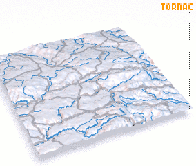 Places with similar names to Tornac, France ::
Disclaimer :: Information on this page comes without warranty of any kind |
||
|
Where is Tornac? Elevation and coordinates ::
Latitude (lat): 44°1'0"N Longitude (lon): 3°59'0"E
Elevation (approx.): 202m (map arrows pan, magnifying glasses zoom) |
||
|
Visiting Tornac? Hotel/Accommodation ::
Book a hotel in Tornac Travel Guide ::
Buy a travel guide for France rental cars ::
car rental offers GPS waypoint ::
download a GPX waypoint (PoI) of Tornac for your GPS receiver
|
||