|
search place name
|
||
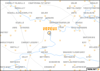
Véreux (Franche-Comté, France)Véreux is a town in the Franche-Comté region of France. An overview map of the region around Véreux is displayed below.
regional and 3d topo map of Véreux, France ::
Véreux airports ::
The nearest airport is DIJ - Dijon Longvic, located 50.5 km south west of Véreux.
Other airports nearby include DLE - Dole Tavaux (55.7 km south), EPL - Epinal Mirecourt (95.2 km north), XCD - Chalon Champforgeuil (99.4 km south west), ENC - Nancy Essey (137.7 km north), Nearby towns ::
Montureux-et-Prantigny (2.2km south west) //
Quitteur (3.1km north east) //
Beaujeu-Saint-Vallier-et-Pierrejux (3.1km south east) //
Dampierre-sur-Salon (4.5km north east) //
Denèvre (5.6km north) //
Rigny (5.7km south) //
Autet (5.3km north east) //
Montot (6.1km north west) //
Delain (7.5km north) //
Ancier (7.5km south) //
Achey (6.7km north west) //
Chargey-lès-Gray (6.2km south west) //
Saint-Broing (8.3km south east) //
Frânois (8.9km north west) //
Mont-le-Frânois (8.9km north west) //
Gray (8.9km south west) //
Arc (8.9km south west) //
[all distances 'as the bird flies' and approximate] 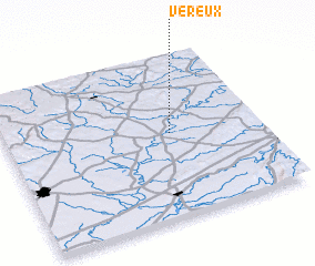 Places with similar names to Véreux, France ::
Disclaimer :: Information on this page comes without warranty of any kind |
||
|
Where is Véreux? Elevation and coordinates ::
Latitude (lat): 47°31'0"N Longitude (lon): 5°39'0"E
Elevation (approx.): 196m (map arrows pan, magnifying glasses zoom) |
||
|
Visiting Véreux? Hotel/Accommodation ::
Book a hotel in Véreux Travel Guide ::
Buy a travel guide for France rental cars ::
car rental offers GPS waypoint ::
download a GPX waypoint (PoI) of Véreux for your GPS receiver
|
||