|
search place name
|
||
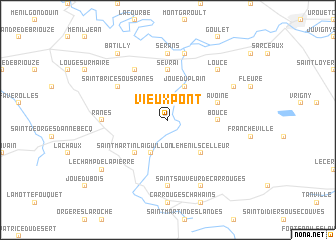
Vieux-Pont (Basse-Normandie, France)Vieux-Pont is a town in the Basse-Normandie region of France. An overview map of the region around Vieux-Pont is displayed below.
regional and 3d topo map of Vieux-Pont, France ::
Vieux-Pont airports ::
The nearest airport is CFR - Caen Carpiquet, located 62.2 km north of Vieux-Pont.
Other airports nearby include LVA - Laval Entrammes (81.6 km south west), LME - Le Mans Arnage (82.2 km south), DOL - Deauville St Gatien (82.6 km north), LEH - Le Havre Octeville (99.8 km north), Nearby towns ::
Sainte-Marie-la-Robert (3.9km south) //
Joué-du-Plain (3.9km north) //
Le Ménil-Scelleur (4.4km south east) //
Saint-Martin-lʼAiguillon (4.4km south west) //
Boucé (3.7km east) //
Sevrai (5.6km north) //
Avoine (4.1km north east) //
Saint-Brice-sous-Rânes (5.2km north west) //
Saint-Ouen-sur-Maire (6.1km north west) //
Sérans (7.4km north) //
Sainte-Marguerite-de-Carrouges (7.4km south) //
Rânes (4.9km west) //
Écouché (7.5km north) //
Loucé (6.7km north east) //
Saint-Sauveur-de-Carrouges (7.8km south) //
Tanques (6.1km north east) //
Le Champ-de-la-Pierre (7.4km south west) //
Batilly (8.3km north west) //
[all distances 'as the bird flies' and approximate]  Places with similar names to Vieux-Pont, France ::
// Vieux-Pont (FR)
// Fox Point (US)
Disclaimer :: Information on this page comes without warranty of any kind |
||
|
Where is Vieux-Pont? Elevation and coordinates ::
Latitude (lat): 48°39'0"N Longitude (lon): 0°9'0"W
Elevation (approx.): 196m (map arrows pan, magnifying glasses zoom) |
||
|
Visiting Vieux-Pont? Hotel/Accommodation ::
Book a hotel in Vieux-Pont Travel Guide ::
Buy a travel guide for France rental cars ::
car rental offers GPS waypoint ::
download a GPX waypoint (PoI) of Vieux-Pont for your GPS receiver
|
||