|
search place name
|
||
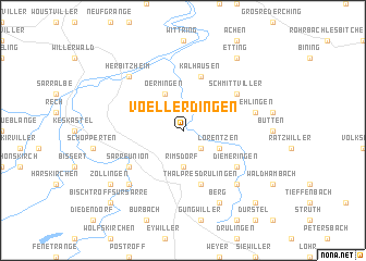
Voellerdingen (Alsace, France)Voellerdingen is a town in the Alsace region of France. An overview map of the region around Voellerdingen is displayed below.
regional and 3d topo map of Voellerdingen, France ::
Voellerdingen airports ::
The nearest airport is SCN - Saarbruecken Saarbrucken, located 27.6 km north of Voellerdingen.
Other airports nearby include SXB - Strassbourg Entzheim (59.9 km south east), RMS - Ramstein Ab (62.4 km north east), ETZ - Metz Nancy Lorraine (64.6 km west), ENC - Nancy Essey (73.0 km south west), Nearby towns ::
Domfessel (2.2km south east) //
Rimsdorf (3.7km south) //
Oermingen (3.9km north) //
Lorentzen (3.1km south east) //
Thal-près-Drulingen (5.7km south) //
Kalhausen (5.7km north) //
Schmittviller (5.2km north east) //
Diemeringen (5.2km south east) //
Sarre-Union (5.2km south west) //
Dehlingen (5.2km east) //
Mackwiller (6.7km south east) //
Sarrewerden (6.7km south west) //
Herbitzheim (6.6km north west) //
Berg (7.8km south) //
Zollingen (7.4km south west) //
Etting (8.3km north east) //
Bischtroff-sur-Sarre (8.9km south west) //
Adamswiller (8.9km south east) //
[all distances 'as the bird flies' and approximate]  Places with similar names to Voellerdingen, France ::
// Vlaardingen (NL)
Disclaimer :: Information on this page comes without warranty of any kind |
||
|
Where is Voellerdingen? Elevation and coordinates ::
Latitude (lat): 48°58'0"N Longitude (lon): 7°8'0"E
Elevation (approx.): 228m (map arrows pan, magnifying glasses zoom) |
||
|
Visiting Voellerdingen? Hotel/Accommodation ::
Book a hotel in Voellerdingen Travel Guide ::
Buy a travel guide for France rental cars ::
car rental offers GPS waypoint ::
download a GPX waypoint (PoI) of Voellerdingen for your GPS receiver
|
||