|
search place name
|
||
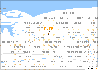
Ewer (Friesland, Netherlands)Ewer is a town in the Friesland region of Netherlands. An overview map of the region around Ewer is displayed below.
regional and 3d topo map of Ewer, Netherlands ::
Ewer airports ::
The nearest airport is GRQ - Groningen Eelde, located 27.7 km south east of Ewer.
Other airports nearby include BMK - Borkum (37.0 km north east), LWR - Leeuwarden (42.1 km west), EME - Emden (57.7 km east), NRD - Norderney (70.8 km north east), Nearby towns ::
Lammerburen (1.9km south) //
Zuurdijk (1.1km east) //
Houwerzijl (1.1km west) //
Electra (2.2km south west) //
Aalsum (3.7km south) //
Englum (2.9km south east) //
Kenwerd (3.9km south) //
Stort (2.9km north east) //
Douwen (2.9km north east) //
Kattenburg (2.9km north east) //
Korhorn (3.9km south) //
Ruigezand (2.9km south west) //
Grijssloot (3.9km north) //
Leens (3.9km north) //
Niekerk (2.9km north west) //
Klei (3.9km north) //
Selwerd (4.3km south east) //
Oldehove (4.3km south east) //
Ulrum (4.3km north west) //
Hornhuizen (5.6km north) //
Niehove (5.6km south) //
Heereburen (5.6km south) //
Kruisweg (5.7km north) //
Frytum (5.7km south) //
De Ruigewaard (3.8km south west) //
Saaksum (3.8km south east) //
Heereburen (5.7km south) //
Kloosterburen (6.0km north) //
Kommerzijl (6.0km south) //
[all distances 'as the bird flies' and approximate] 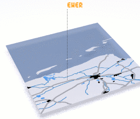 Places with similar names to Ewer, Netherlands ::
Disclaimer :: Information on this page comes without warranty of any kind |
||
|
Where is Ewer? Elevation and coordinates ::
Latitude (lat): 53°20'0"N Longitude (lon): 6°22'0"E
Elevation (approx.): 1m (map arrows pan, magnifying glasses zoom) |
||
|
Visiting Ewer? Hotel/Accommodation ::
Book a hotel in Ewer Travel Guide ::
Buy a travel guide for Netherlands rental cars ::
car rental offers GPS waypoint ::
download a GPX waypoint (PoI) of Ewer for your GPS receiver
|
||