|
search place name
|
||
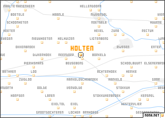
Holten (Overijssel, Netherlands)Holten is a town in the Overijssel region of Netherlands. An overview map of the region around Holten is displayed below.
regional and 3d topo map of Holten, Netherlands ::
Holten airports ::
The nearest airport is ENS - Enschede Twenthe, located 30.1 km east of Holten.
Other airports nearby include UTC - Soesterberg (81.0 km west), FMO - Muenster/osnabrueck Munster Osnabruck (87.1 km east), GRQ - Groningen Eelde (93.6 km north), ESS - Essen Mulheim (104.0 km south), Nearby towns ::
Look (0.0km north) //
Beuseberg (2.2km south west) //
Neerdorp (2.3km west) //
Borkeld (2.3km east) //
Helhuizen (4.3km north west) //
Ligtenberg (4.3km north east) //
Markeloschebroek (5.6km south) //
Achterhoek (5.0km south east) //
Hexel (6.0km north) //
Espelo (5.0km north west) //
Verwolde (7.5km south) //
Noetsele (7.8km north) //
Zuna (7.2km north east) //
Beusbergen (7.2km south east) //
Markelo (7.2km south east) //
[all distances 'as the bird flies' and approximate] 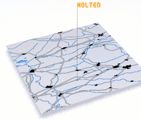 Places with similar names to Holten, Netherlands ::
Disclaimer :: Information on this page comes without warranty of any kind |
||
|
Where is Holten? Elevation and coordinates ::
Latitude (lat): 52°17'0"N Longitude (lon): 6°26'0"E
Elevation (approx.): 22m (map arrows pan, magnifying glasses zoom) |
||
|
Visiting Holten? Hotel/Accommodation ::
Book a hotel in Holten Travel Guide ::
Buy a travel guide for Netherlands rental cars ::
car rental offers GPS waypoint ::
download a GPX waypoint (PoI) of Holten for your GPS receiver
|
||